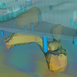
Quantify contaminated volumes quickly and accurately with Kartotrak’s “volumes & excavation” module
Posted on
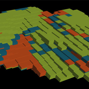
Kartotrak’s “Volumes & Excavation” workflow is a real decision-making tool. It enables precise cost-benefit analyses by quantifying the masses and volumes of soil to be treated according to different rehabilitation thresholds and the risk of residual pollution.
Quantifiez avec précision et rapidité les volumes contaminés avec le module “Volumes & Excavation” du logiciel Kartotrak
Posted on
Le workflow “Volumes & Excavation” de Kartotrak est un véritable outil d’aide à la décision. Il permet des analyses coûts-bénéfices précises en quantifiant les masses et volumes de sol ou terres à traiter en fonction de différents seuils de réhabilitation et du risque de pollution résiduelle.
Geostatistical simulations, what for? Geovariances’ consultants give examples of use
Posted on
We asked some of our consultants to tell us about recent studies in which they used conditional simulations for specific issues. Here are the examples they gave us.
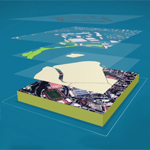
Enrich your maps with background images: discover a list of websites from where you can download spatial data for free
Posted on
There is no better way to understand your data than to display it in its global environmental context. Geovariances software solutions, Isatis.neo and Kartotrak, embed GIS components for the 2D display of data of any kind (points, borehole tops, grids, polylines, polygons) in several layers. It is then easy to enrich your maps by adding background images imported from geographic raster or vector files.
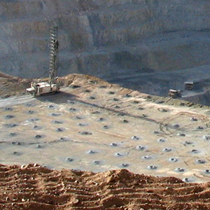
Drilling optimization through DHSA
Posted on
Read how Geovariances’ consultants help a copper mine in Brazil to reduce the grade uncertainty of ore concentrates to better meet customers’ requirements.
DiscoverMine Radio podcast – Episode 24: Conditional simulation and uncertainty in the ore body by David Barry
Posted on
David Barry, Senior Geostatistician and a Geovariances’ Perth-based consultant, has been invited by DiscoverMine Radio to explain conditional simulation as one method used in the mining operation to better estimate the ore body. Listen to the recording and learn what conditional simulations are, how they differ from classic mining geostatistics techniques.
DiscoverMine Radio podcast – Episode 23: An introduction about geostatistics in a mining operation by Marlene Woligroski
Posted on
Marlene Woligroski, geologist and business development manager for the Asia Pacific region, has been invited by DiscoverMine Radio to introduce and explain the interests of geostatistics and the benefits offered by our software Isatis.neo.
Things I’ve done with Python in Isatis.neo
Posted on
Discover what our senior geostatistician David Barry does in Isatis.neo with the power of Python scripting.
A sampling guide for improved nuclear site characterization – H2020 INSIDER
Posted on
Learn more about a sampling strategy for improved nuclear site characterization and waste reduction in decommissioning projects. Read the two latest technical articles by Geovariances, in partnership with SCK.CEN and CEA.
Available in Isatis.neo: an innovative way of classifying mineral resources
Posted on
With the “Sampling Density Variance” tool, Isatis.neo offers an innovative methodology allowing robust resource classification, independent from sample number, block size, and domain extension.