Contamination characterization software
Kartotrak
Kartotrak guides you through the full characterization workflow, from field data to contamination maps and volume estimates, so you can plan your remediation with confidence.
From field data to remediation decision, in a single tool.
Data Loading & Quality Control
Import, validate, and structure all available site data into a single database.
Conceptual Site Model & 2D/3D Vizualisation
Build your understanding of the contamination: spatial structure, history, and key uncertain areas.
Sampling Plan Optimization
Design cost-effective investigation campaigns: target new samples where uncertainty is highest.
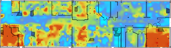
2D/3D Contamination Mapping
Produce kriged contamination maps with uncertainty quantification, per pollutant, per depth.
Volume Estimation & Uncertainty Quantification
Estimate contaminated soil volumes per contaminant and per threshold, with full uncertainty and confidence intervals.
Risk Analysis & Remediation Planning
Turn simulation outputs into excavation plans and remediation decisions.
Reporting & Auditability
Generate regulatory-compliant reports at any stage, traceable, reproducible, export-ready.
Why Professionals Choose Kartotrak
Integrated Workflow
From field data to remediation plan in a single platform. No need to switch between tools.
2D/3D Visualization
Integrated GIS and 3D viewer for chemical and radiological data. Combines aerial photos, historical data, geophysical data and boreholes.
Sampling Optimization
Identify under-sampled areas and high-uncertainty zones. Reduce investigation costs without compromising reliability.
Proven Geostatistics
Built on Geovariances' 40 years of geostatistical expertise. Reliable maps, auditable results.
Regulatory Compliance
MARSSIM statistical tests built in. Reports compatible with French and international regulatory requirements
Expert Support
Training, consulting, and support from Geovariances geostatisticians experienced in contaminated sites and nuclear decommissioning. Response guaranteed within 24 hours.
Guided Demo
On real contamination data, with a Geovariances geostatistician.
Request a demo arrow_forwardFree Trial
Full access to Kartotrak for 2 weeks to 1 month, no commitment.
Start evaluation arrow_forwardTalk to an Expert
A geostatistician specialized in contaminated sites will guide you, free of charge, within 48 hours.
Submit your request arrow_forwardTechnical Resources
Demos, webinars and technical articles to discover the full potential of Kartotrak.
Access resources arrow_forwardNeed broader geostatistical analysis?
Isatis.neo covers the full range of geostatistical methods, estimation, simulation, and risk analysis. All Kartotrak intermediate files can be exported for advanced analysis in Isatis.neo.
Discover Isatis.neo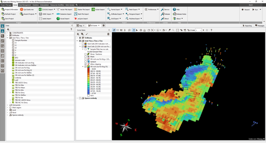
"Today, I believe that uncertainties can no longer be ignored. And Kartotrak is one of the tools on the market that allows us to take them into account."
"In contaminated sites and soils, we have an obligation of means and a duty of advice to our clients. It is essential to be able to evaluate uncertainties, not only qualitatively but also quantitatively."
"Kartotrak enables rapid quality control of survey data. The software facilitates the interpretation and communication of results by displaying vertical profiles, organized by survey group, in 2D or 3D."
Questions fréquentes
Tout ce que vous voulez savoir avant de nous contacter
What is Kartotrak used for? expand_more
Kartotrak is used to characterize contaminated sites and soils, mapping the spatial distribution of pollutants, estimating contaminated soil volumes, and supporting remediation and decommissioning decisions. It covers both chemical contamination (hydrocarbons, metals, solvents, BTEX, HAPs) and radiological contamination (nuclear facilities and decommissioning projects). Kartotrak can be used at any stage of a remediation project: during the scoping and characterization phase, during remediation to guide excavation, or after remediation to verify site compliance with cleanup regulatory objectives.
What is the difference between Kartotrak and Isatis.neo? expand_more
Kartotrak is a dedicated, turnkey solution specifically designed for contaminated site characterization. Its workflow is preconfigured, and guides users step by step — from data loading and quality control to volume estimation and remediation planning — without requiring advanced geostatistical knowledge. Isatis.neo is a general-purpose geostatistics platform covering a much wider range of methods and industries. Both are developed by Geovariances, and Kartotrak intermediate files can be exported to Isatis.neo for advanced analysis or visualization.
Can Kartotrak handle both chemical and radiological contamination? expand_more
Yes. Kartotrak was originally developed for radiological characterization in nuclear facilities, in partnership with the French Atomic Energy Commission (CEA). It has since been extended to fully cover chemical contamination. For radiological applications, Kartotrak connects directly with in-situ measurement devices, including gamma spectrometers, scintillation detectors, ORTEC products, Canberra germanium detectors, and Saphymo DSP detectors, enabling real-time 2D data acquisition on radioactively contaminated sites. For chemical contamination, it handles multi-pollutant scenarios with distinct regulatory thresholds for each pollutant and can derive contaminated masses and soil volumes for each substance.
Does Kartotrak comply with MARSSIM and other regulatory standards? expand_more
Kartotrak includes the statistical tests from the MARSSIM guidebook (Multi-Agency Radiation Survey and Site Investigation Manual), used in the United States to verify site compliance with cleanup objectives. It is compatible with French regulatory requirements and produces auditable, reproducible outputs with full parameter traceability, meeting the documentation requirements of French and international regulatory authorities.
How does Kartotrak help reduce remediation costs? expand_more
Kartotrak reduces costs at two key stages. During the investigation, it identifies under-sampled and high-uncertainty zones, so that additional sampling is targeted only where it adds real value, avoiding unnecessary field campaigns. During remediation planning, its geostatistical volume estimation and risk analysis tools enable accurate sizing of the excavation plan, striking the right balance between remediation performance and waste volumes. Studies have shown that errors in volume estimation at the diagnostic stage can exceed 30% in a third of remediation projects; geostatistical methods consistently yield the smallest, least dispersed estimation errors.
How does Kartotrak estimate contaminated soil volumes and quantify uncertainty? expand_more
Kartotrak manages volume estimation uncertainty through two complementary approaches. The first is kriging, which produces the most probable estimate of the contamination at each unsampled location along with a local confidence indicator — the kriging variance — that quantifies how reliable each estimate is. The second is geostatistical simulation, which generates a set of equally probable realizations of the contamination. From these realizations, Kartotrak computes exceedance probabilities per regulatory threshold, confidence intervals on contaminated volumes, and risk-based classification of soil zones. This dual approach enables decisions that are grounded in the full range of possible outcomes — not a single deterministic model — which is essential for defensible excavation planning and regulatory reporting.
Can Kartotrak be used for realtime on-site data acquisition? expand_more
Yes. Kartotrak can be deployed directly in the field, from a specially equipped vehicle or carried on-site, to acquire and record surface measurements in real time in tandem with a differential GPS for precise localization of sampling points. It connects with a wide range of insitu measurement devices, including all ORTEC products, Canberra germanium detectors, and Saphymo DSP detectors. As new measurements are acquired, Kartotrak updates the site model dynamically, enabling real-time mapping of covered areas — even very large ones — and informing decisions on where to focus additional investigation.
What file formats and software does Kartotrak connect to? expand_more
Kartotrak supports the data formats standard in environmental site investigation: CSV, Excel, and geographic vector files (SHP, DXF, GeoTIFF, MapInfo, ESRI Shapefile). Results are exported with full georeferencing information as GeoTIFF, ArcGIS, or NetCDF files. For radiological applications, Kartotrak connects directly with a range of in-situ measurement devices, including all ORTEC products, CSP probes from Mirion Technologies (Canberra), and the Saphymo DSP detector. All Kartotrak intermediate files can be exported to Isatis.neo for advanced geostatistical analysis
What level of expertise is required to use Kartotrak? expand_more
Kartotrak is designed to make geostatistics accessible to environmental engineers and site managers who are not geostatistical specialists. Its preconfigured workflow, intuitive interface, and guided steps allow users to produce reliable results without advanced statistical knowledge. Geovariances also offers training courses from introductory to advanced levels, specifically calibrated for contaminated site applications.
Is Kartotrak right for my project? expand_more
If your project involves characterizing contamination, estimating volumes to be treated, or planning a remediation or decommissioning program, Kartotrak is designed for you. Contact our team, and a Geovariances geostatistician will guide you free of charge within 48 hours toward the most appropriate solution.
Contactez nos experts
Prêt à transformer vos données en décisions ? Nos experts vous répondent sous 48h.
Head Office
44 Avenue de Valvins, 77210 Avon, France