Biological resources are numerous and of vital interest: fisheries and shellfisheries, forestry, etc. Their monitoring has multiple goals: stock assessment, understanding of their spatial distribution, dynamics and relationship between the resource and its environmental context, health risk forecast.
Spatial and temporal data collected in the framework of this monitoring benefit from a geostatistical analysis for various reasons: data analysis, sampling optimization, multivariate mapping and risk analysis.
Geostatistics applied to biological resource modeling
STOCK ASSESSMENT
Geostatistics provides a relevant solution aiming at estimating globally the resource stock, together with an estimate of the related uncertainty (kriging variance). This stock assessment is impacted by the spatial structure of the resource distribution, captured with the variogram. Stock assessment then allows setting up relevant constraints about the resource use in order to ensure its sustainability.
SAMPLING OPTIMIZATION
The probabilistic framework of geostatistics enables the calculation of different uncertainty indices such as the estimation variance or confidence intervals related to the estimate of the target variable. Therefore, it is possible to tune additional sample locations to reduce specific uncertainty criteria. In the case of the estimation variance, as this one only depends on the spatial structure and the data configuration, additional samples will be located in under-sampled areas. Points located to reduce confidence intervals around kriging estimates will be expected to be in areas with high variability.
BETTER UNDERSTANDING OF RESOURCE BEHAVIOUR
Exploratory data analysis first allows identifying and handling data anomalies and anisotropies using appropriate statistical representations: basemap, histogram, q-q plot, variogram map, logs, 3D viewer. Analyzing the spatial distribution of the resource and its relationship with its environment improves the understanding of its spatial dynamics. As a consequence, the resource is better managed and potential health risks are better anticipated.
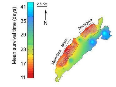
Survival of oysters in the Thau lagoon
Kriged map of the mean survival time of oysters in the Thau Mediterranean lagoon. (Pernet at al., 2014, doi:10.1371/journal.pone.0088469.g002)