Consulting and mentoring services based on high level geostatistics
Geovariances provide consulting and mentoring services worldwide, mainly to the Mining, Energy, Nuclear Decommissioning, Contaminated Sites, and Geotechnical engineering industries, but not only. Our versatile team of consultants combines their extensive experience in using our software and Python with their high level of geostatistics and data science expertise to find innovative solutions to your specific issues.
Their professionalism and flexibility allow them to deliver relevant, practical, and rigorous consulting solutions quickly. Their software experience and industry knowledge help them choose the most suitable methods and tools to process your data properly, deliver controlled and safer models and optimize the results that help your decision-making process. In addition, they have extensive knowledge of communication requirements worldwide and are qualified to prepare independent technical reports in many international jurisdictions.
Mining
We help you improve production and economic performance.
Our services include:
– Geological and metallurgical domain definition using machine learning techniques,
– Resource estimation and classification (according to NI 43-101 and JORC, among others),
– Optimization of short, medium, and long-term estimates,
– Recoverable resource estimation (estimation of tonnage, metal quantity, and grade above chosen cutoffs) and SMU modeling,
– Resource uncertainty characterization,
– Drill hole spacing optimization.
Contaminated Sites and Nuclear Decomissioning
We help you design more effective remediation and decommissioning scenarios.
Our services include:
– Detailed data analysis and quality control and delivery of critical statistics,
– Optimization of investigation density and location,
– Delimitation of contamination sources and concentrated pollutions,
– 3D modeling of deep contamination
– Quantification of masses of contaminants and volumes of soil to be treated according to remediation thresholds,
– Classification of contaminated areas and wastes with a quantified risk analysis,
– Optimization of waste treatment routes,
– Sizing of management solutions (mass balance, cost-benefit balance, excavation maps, etc.).
Geotechnical engineering
We help you improve your understanding of ground conditions and better handle risks.
Our services include:
– 3D modeling of the geology and geotechnical parameters,
– Subsurface variability characterization,
– Geotechnical risk characterization with the delivery of several scenarios (for example, of the parameters measuring the geomechanical constraints or soil deformation),
– Modeling of aquifer geometry,
– Optimization of measurement networks.
Oil and gas
We help you assess better the economic viability of your project.
Our services include:
– Filtering of acquisition or processing artifacts in seismic cubes,
– Merging of seismic cubes,
– Time-to-depth conversion,
– Definition of stratigraphic units,
– Lithofacies and geology modeling,
– Assistance in petrophysical and geomechanical modeling,
– Geobodies connectivity analysis,
– Identification of spill points and delineation of potential reservoir traps,
– Production of various scenarios of potentially recoverable resources and gross rock volumes.
Air, water, soil, bioresources, and other sectors
We help you reveal the information behind your data.
Our services include
– Air quality monitoring: mapping of pollutants, air quality indices or population exposure to air pollution, optimisation of measurement networks.
– Bathymetry: seabed mapping, uncertainty analysis.
– Bioresources (forestry, fishery, ..): stock assessment, health risk evaluation.
– Precision agriculture: yield mapping, identification of homogeneous areas.
– Any sector dealing with spatial data, i.e. climatology, geochemistry, epidemiology, archaeology: mapping, risk analysis.
Automation, customization and review of workflows
We help you be more efficient with our software solutions and quickly deliver the results your company expects.
Our services include:
– Automation of estimation routines,
– Optimization of estimation parameters,
– Review and optimization of your current process,
– Converting routines from Isatis or other software to Isatis.neo,
– Building and delivery of workflows using Isatis.neo and Python packages,
– Mentoring to assist you in setting up your workflow based on your data and objectives.
Hear from our clients
Some of our achievements
-
MiningYamana
Automation of a resource estimation workflow using Python and batch coding.
KNSKoniambo Nickel DepositRecoverable Resource Estimation using Multivariate Direct Block Simulation
BHPOperating Coal MineBenchmarking local uncertainty characterization using kriging variance, DHSA and conditional simulations
-
Oil and GasWoodside
Filtering and merging of velocity cubes
RepsolCharacterization of a stochastic inversion
Circle OilCharacterization of seismic data with connectivity criteria
-
Nuclear DecommissioningCEA, FranceMarcoule
Estimation of contaminated soil amounts and contamination levels and geological and underground-layers mapping.
Onet Technologie, FranceGeostatistical deconvolution to
find and locate punctual sources.Framatome, FranceMetallographic characterization by variographic analysis and geostatistical simulation of local segregation microstructures.
Resources
-
Kartotrak – Renforcez la précision de vos diagnostics de sites contaminés et optimisez vos plans de réhabilitation et de démantèlement avec la géostatistique | Optimisez vos campagnes d’échantillonnage et réduisez les coûts. Affinez la caractérisation de contaminations chimiques ou radioactives. Trouvez le juste équilibre entre performance de la réhabilitation et volume de déchets grâce à des analyses de risque robustes.
-
Kartotrak – Improve contaminated site diagnosis and optimize remediation and decommissioning plans with geostatistics | Optimize sampling campaigns and save on costs. Improve contamination characterization, whether chemical or radioactive. Balance remediation efficiency and waste volumes and make the best decision.
-
Isatis.neo – Révélez la véritable nature du sous-sol – Développez votre compréhension de sa structure et de son hétérogénéité | Grâce à la géostatistique, transformez vos données en une vision claire et cohérente du sous-sol. Réduisez les incertitudes, optimisez vos modèles et prenez des décisions éclairées en toute confiance.
-
Isatis.neo – Reveal the true nature of the subsurface. Gain a reliable understanding of subsoil structure and heterogeneity | Integrate geostatistics into your modeling workflow to uncover deeper insights, reduce uncertainty, and make smarter, risk-informed decisions with confidence.
-
Geovariances – Consulting Services for the Mining Industry
Use of Simulations for Mining Applications
Linear interpolation techniques – such as kriging – are inappropriate for dealing with issues that require a full characterization of spatial distribution (for example, probability of exceeding a threshold, variability of a product per mining period, recoverable resources at various cut-offs, etc.).
Only conditional simulations reproduce the true variability of your orebody. They are flexible in their application to complex mining processes and uncertainty assessment.
Through Geovariances’ multiple experiences in developing a variety of simulation strategies in different environments: kimberlite pipes, turbiditic and carbonate reservoirs, porphyry copper, alteration and hyd,rothermal type deposits, learn how geostatistical simulations can help in resource estimation and classification.

Hydrogeological Facies Modeling
Stochastic Methods for geological modeling and links with fluid flow simulations
Whatever the application domain – oil & gas production, aquifer pollution characterization, uranium production by lixiviation – characterizing the geological parameters and capturing their variability is essential to ensure realistic flow modeling…

Time to Depth Conversion
Time to depth conversion of geological surfaces is critical for structural model building. Quantifying the uncertainty attached to the conversion is also of primordial importance for assessing GRV uncertainties. Traditional velocity models used in time to depth conversion could benefit from geostatistical techniques used in data integration. The advantage of using geostatistical methods is that they fit the data in one step and allow quantifying the uncertainty attached to the prediction by mean of the generation of equiprobable realizations.
Through Geovariances long-lasting experience in geostatistical depth conversion studies, learn how geostatistics helps you improve the accuracy of your reservoir structural model and assess the uncertainties on surfaces.
Mapping with auxiliary data
Through this white paper, discover how you canimprove significantly map reliability and quality by incorporating various sources of information in the interpolation process.
This document details the different methods for assimilating various sources of information, taking into account the reliability of each source and how the uncertainty associated with any mapping result can be estimated and reduced.

Data Quality Control
Before starting an evaluation of the contamination leading to decision-making tools for site clean-up, it is essential to ensure data quality. Thus, based on solid and reliable foundations, uncertainties occurring during the different steps of the decision process will be better controlled and the final quality of the project improved.
The objective of this white paper is to assess at best the validity of the data through visual, statistical and geostatistical basic tools before going further into their analysis.
-
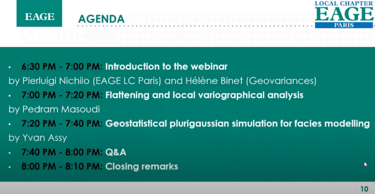
Application de la géostatistique dans l’analyse de risque géotechnique lié à la liquéfaction du sol (vidéo) | Gestion des Données et Nouvel Environnement numérique en Géotechnique - Journée technique CFMS 15 nov 2022
-
Methodology for the Estimation of Contaminated soil by a Geostatistics-based method | WM2023 - E. Moreno (CEA Marcoule), Y. Desnoyers (Geovariances), I. Bisel (CEA Marcoule) and P. Marty (CEA Marcoule)
-
Utilisation d’un algorithme de classification par Machine Learning pour la caractérisation géomécanique des sols | CFMS 2020 - par Marie-Cecile Febvey
-
Contributions of the CETAMA working group n°10 on sampling and radiological characterisation (poster) | Anne Courtadon et Danièle Roudil, CEA Marcoule; Yvon Desnoyers, Geovariances; Didier Dubot, CEA; Guy Granier, IRSN; Catherine Ollivier-Dehaye, EDF
-
Geostatistical study to support sustainable remediation of a site with historical lead impact (poster) | Claire FAUCHEUX, Nicolas JEANNEE, Perrine MARTIN , Maarten CUYPERS, Annelies JACOBS
-
Probabilistic Modeling of Lateritic Nickel Mineral Resources | R. Rolo (Geovariances), J. Arief (Vale Indonesia) and S. Yuminti (Vale Indonesia) - Published in Minerals 16, no. 5: 551.
-
Spatial uncertainty quantification of extreme cold temperature return periods in Quebec using multivariate turning bands simulation | D. Tapsoba (Hydro-Québec), P. Masoudi (Geovariances) & X. Emery (Universidad de Chile) – Stoch Environ Res Risk Assess 40, 110 (2026)
-
Applicability of predicted cone penetration test profiles from geostatistical co-simulation on deterministic and probabilistic monopile foundation design for offshore wind turbines | Authors: L. Siemann (IWES), S. Wilhelm (GuD Consult), P. Masoudi (Geovariances), R. Relanez (IWES), P. Arnold (GuD Consult), B. Schwarz (IWES), F. Rackwitz (Technical University of Berlin), T. Mörz (University of Bremen) - Published in Ocean Engineering, Volume 355, Part 2, 2026
-
Probabilistic Modeling of Hourly Precipitation Jointly with ERA5-Land: Application of Geostatistical Simulations | Tapsoba D. (Hydro-Québec Research Institute (IREQ)), Rousseau-Rizzi (Hydro-Québec Research Institute (IREQ)), R., Masoudi P. (Geovariances), Lemarchand O. (Geovariances) - Published in Save article Mathematical Geosciences (2026)
-
Stratigraphic and Geotechnical Modelling by Geostatistics, Applied to Penetrometer and Menard Pressure-Meter Tests | Masoudi, P., Simon, C., Faucheux, C. et al. - Mathematical Geosciences (2025). https://doi.org/10.1007/s11004-025-10242-0