Skip to content

Geovariances is a Datamine company.    X

THE GLOBAL PROVIDER OF GEOSTATISTICS-BASED SOLUTIONS

   Access our blog  |  Subscribe to our newsletters  |  Contact us
    MY GEOVARIANCES        LOG IN   
Logo Geovariances
  • Industries
    • Mining Industry
    • Oil & Gas Industry
    • Nuclear Decommissioning
    • Contaminated Sites
    • Air, water, soil, bioresources and other
  • Software
    • Isatis.neo, accessible powerful geostatistics
    • Kartotrak, for contaminated site characterization
    • Isatis.py, Python package in geostatistics
    • On demand library and application development
    • Innovation
    • Technical support
  • Consulting
  • Training
    • Training offer
    • Upcoming training sessions
    • Training catalog
  • Resources
  • About us
    • What our clients say about us
    • Who we are
    • News
    • Events
KARTOTRAK.ONE

THE EASY ROUTE TO SITE REMEDIATION

As a player involved in site characterization projects, your decisions are often based on limited and heterogeneous data.
So, how to predict the degree of contamination and how to propose an appropriate remediation strategy?
We provide Kartotrak.one, an easy-to-use and fast application for in-depth data analysis and quality control and accurate contamination mapping. 

Improve your understanding of the contamination

With Kartotrak.one, you put all available data in their global environmental context and get the tools to analyse them thoroughly. The software generates professional quality displays facilitating communication between project stakeholders.

Base your decisions on reliable information

Adopting Kartotrak.one means you get the realistic and reliable contamination maps you need to make informed decisions and better anticipate issues related to site remediation. Hot spots or under-sampled areas are immediately located.

Save time during site characterization

Using Kartotrak.one, you enjoy the efficiency with which a map is produced. You optimize your time using the same software from data analysis to excavation plan. Besides, Kartotrak.one is relevant for any type and any size of project.

KARTOTRAK.ONE KEY FEATURES

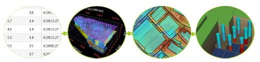
  • Integration and visualization of all available data (surveys, surface measurements, DTM, aerial views, plans, etc.)
  • Data controlled and validated through high-value exploratory data analysis tools
  • Fast 2D and 3D mapping based on quality geostatistics
  • Production of excavation plans (Click here for more info)
  • Integrated workflow
  • Combined GIS and 3D viewer for professional displays
  • User-friendly interface
  • Fast to learn and to handle


ASK FOR MORE INFO OR REQUEST YOUR FREE TRIAL OF KARTOTRAK.ONE →


Kartotrak.one is a light version of Kartotrak. The software gathers Kartotrak exploratory data analysis and rapid mapping functionalities. Kartotrak, in its full version, enables more advanced geostatistical data modeling and uncertainty quantification associated with contaminated volumes or masses of pollutants. It can also model several pollutants together.

Contact

info@geovariances.com
EUROPE, AFRICA, ASIA, OCEANIA
Tel +33 (0)1 6074 9090
NORTH AMERICA
Tel +1 437 432 3346
SOUTH AMERICA
Tel +55 11 98384 9716

ANY QUESTIONS ?

If you would like to discuss your needs or an upcoming project, please feel free to contact us by completing this form.

Fill the form

MEDIA

  • Newsletter subscription
  • Blog posts
  • Press releases
  • Press review

CONNECT WITH US

Find our Jobs
©2025 Geovariances — All rights reserved. Privacy Policy, terms & conditions
website v2.757-3424654-develop - 2024-08-28@17:49:08

Operation in progress, please wait...


We use cookies on this website to enhance your user experience.

By continuing to navigate on this site, you accept that we deploy the strictly necessary cookies for its proper functioning and measuring traffic.

Note that our videos are hosted by Youtube. By watching them, you accept the terms and conditions of www.youtube.com.
Read our Privacy and Cookies Policy.

Got it

LOGIN TO OUR WEBSITE

Business Email *


Why be authenticated on our website?

• To have free access to your private space MY GEOVARIANCES for software and technical documentation download
• To benefit from free download of technical resources
• To fill any form without entering details again and again
• To register for a training course or a seminar in one mouse click

For any question, please contact webmaster@geovariances.com


Stay current with our news

Get some tips on how to use our software solutions. Be the first to hear about software updates and new features, the publication of blog articles, white papers or client stories. Keep your agenda up to date with our training sessions, webinars, and workshops.

Subscribe now to our emails, newsletters, and/or blog.

> SUBSCRIBE

MAKE AN ENQUIRY

If you have questions or would like to discuss your needs or an upcoming project, please feel free to contact us by completing this form. We are happy to help.