Skip to content

Geovariances is a Datamine company.    X

THE GLOBAL PROVIDER OF GEOSTATISTICS-BASED SOLUTIONS

   Access our blog  |  Subscribe to our newsletters  |  Contact us
    MY GEOVARIANCES        LOG IN   
Logo Geovariances
  • Industries
    • Mining Industry
    • Oil & Gas Industry
    • Nuclear Decommissioning
    • Contaminated Sites
    • Air, water, soil, bioresources and other
  • Software
    • Isatis.neo, accessible powerful geostatistics
    • Kartotrak, for contaminated site characterization
    • Isatis.py, Python package in geostatistics
    • On demand library and application development
    • Innovation
    • Technical support
  • Consulting
  • Training
    • Training offer
    • Upcoming training sessions
    • Training catalog
  • Resources
  • About us
    • What our clients say about us
    • Who we are
    • News
    • Events
PRECISION AGRICULTURE

Farmers have an in-depth knowledge of the physical properties of their fields. Proximal sensing and airborne data are just examples of recent technologies that provide high-resolution insight about the intra-parcel variability. Geostatistics takes benefit of such data and allows refining precision agriculture practices.

Geostatistics applied to precision agriculture practices

DATA AND CORRELATION ANALYSIS

Exploratory data analysis first allows identifying and handling data anomalies and anisotropies using appropriate statistical representations: basemap, histogram, q-q plot, variogram map, logs, 3D viewer. The analysis of the spatial distribution of the variable of interest is based on a spatial correlation function calculated from the sample measurements and known as the variogram. The relationship between the soil data and auxiliary information may also be investigated in order to improve the understanding of the spatial dynamics of soil properties.


DATA INTEGRATION

Data integration is at the heart of precision agriculture. Indeed, as defined by the US National Research Council in 1997: “Precision agriculture is a management strategy that uses information technologies to bring data from multiple sources to bear on decisions associated with crop production”.

Geostatistics provides a full range of methods dedicated to the integration of auxiliary data during the mapping of key variables such as yield or soil properties: cokriging, collocated cokriging, external drift kriging, bayesian kriging, kriging with varying local means, etc.


UNDERSTANDING THE DIFFERENT VARIABILITY SCALES OF SOIL PROPERTIES

Variogram analysis allows identifying different scales of variability for the soil properties. Such scales may be related to farming practices or geological trends. Once identified these different scales, geostatistics provides a solution called factorial kriging that aims at extracting spatial components of particular interest from the overall measured information. This method aims at filtering out components of limited interest or analyzing separately these components.

Potassium mapping

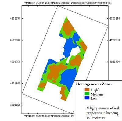
Definition of homogeneous zones (long range component)
Defining homogeneous zones helps guiding more precise water input for irrigation management

DISCOVER OUR SOFTWARE SOLUTIONS →
DISCOVER OUR CONSULTING SERVICES →

Contact

info@geovariances.com
EUROPE, AFRICA, ASIA, OCEANIA
Tel +33 (0)1 6074 9090
NORTH AMERICA
Tel +1 437 432 3346
SOUTH AMERICA
Tel +55 11 98384 9716

ANY QUESTIONS ?

If you would like to discuss your needs or an upcoming project, please feel free to contact us by completing this form.

Fill the form

MEDIA

  • Newsletter subscription
  • Blog posts
  • Press releases
  • Press review

CONNECT WITH US

Find our Jobs
©2025 Geovariances — All rights reserved. Privacy Policy, terms & conditions
website v2.757-3424654-develop - 2024-08-28@17:49:08

Operation in progress, please wait...


We use cookies on this website to enhance your user experience.

By continuing to navigate on this site, you accept that we deploy the strictly necessary cookies for its proper functioning and measuring traffic.

Note that our videos are hosted by Youtube. By watching them, you accept the terms and conditions of www.youtube.com.
Read our Privacy and Cookies Policy.

Got it

LOGIN TO OUR WEBSITE

Business Email *


Why be authenticated on our website?

• To have free access to your private space MY GEOVARIANCES for software and technical documentation download
• To benefit from free download of technical resources
• To fill any form without entering details again and again
• To register for a training course or a seminar in one mouse click

For any question, please contact webmaster@geovariances.com


Stay current with our news

Get some tips on how to use our software solutions. Be the first to hear about software updates and new features, the publication of blog articles, white papers or client stories. Keep your agenda up to date with our training sessions, webinars, and workshops.

Subscribe now to our emails, newsletters, and/or blog.

> SUBSCRIBE

MAKE AN ENQUIRY

If you have questions or would like to discuss your needs or an upcoming project, please feel free to contact us by completing this form. We are happy to help.