Skip to content

Geovariances is a Datamine company.    X

THE GLOBAL PROVIDER OF GEOSTATISTICS-BASED SOLUTIONS

   Access our blog  |  Subscribe to our newsletters  |  Contact us
    MY GEOVARIANCES        LOG IN   
Logo Geovariances
  • Industries
    • Mining Industry
    • Oil & Gas Industry
    • Nuclear Decommissioning
    • Contaminated Sites
    • Air, water, soil, bioresources and other
  • Software
    • Isatis.neo, accessible powerful geostatistics
    • Kartotrak, for contaminated site characterization
    • Isatis.py, Python package in geostatistics
    • On demand library and application development
    • Innovation
    • Technical support
  • Consulting
  • Training
    • Training offer
    • Upcoming training sessions
    • Training catalog
  • Resources
  • About us
    • What our clients say about us
    • Who we are
    • News
    • Events
STRUCTURAL MODELING OF RESERVOIRS

Building accurate geological surfaces in depth is critical for reservoir structural model quality. Geostatistics helps enhancing velocity models used in time-to-depth conversion with data-driven filters for removing acquisition footprints. Data integration capabilities provided by multivariate geostatistics and uncertainty quantification with geostatistical simulations lead to well controlled geological horizons.

Geological structures are classically picked from seismic profiles in the time domain. In order to create a reservoir model or compute volumetrics, these time interpretations need to be converted to depth and calibrated to well markers.


The geostatistical approach has a lot of advantages:


INDEPENDANT DATA QUALITY CONTROL

Time horizons or velocity are commonly impaired by noise, acquisition artifacts or footprints due to seismic processing and/or seismic interpretation. Geostatistics provides adaptive data driven filters based on variogram analysis and factorial kriging to efficiently remove such artifacts.


EXPORATORY DATA ANALYSIS AND DETERMINATION OF VELOCITY FUNCTIONS

Exploratory data analysis allows identifying outliers, data clusters or trends. Also, it helps in understanding the correlation between variables and gives quantitative/qualitative information on major spatial data structures.


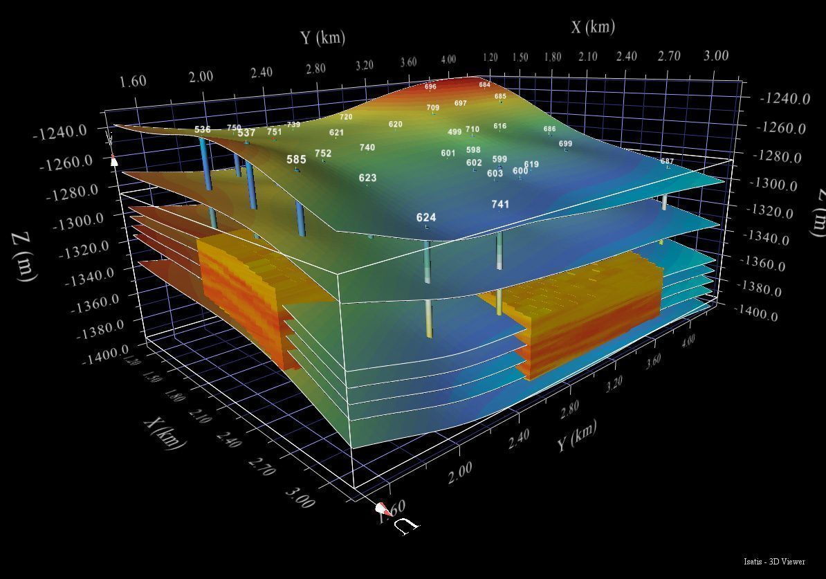
CONTROL OF SPATIAL CONTINUITY AND COHERENCE

The principal benefit of geostatistics is to allow controlling the spatial coherence of data. Geostatistics enables the analysis of seismic data through a probabilistic approach, based on a spatial variability analysis. It characterizes the spatial structure of the parameters.


Reservoir structual modeling with Isatis


INTEGRATION OF VARIOUS DATA

Geostatistics provides algorithms to integrate data of different nature. The main approach used in time-to-depth conversion is kriging with external drift (KED) or kriging with Bayesian drift. It is an exact interpolator, meaning that the well data are honored. In addition KED accounts for trends thus replicating strong spatial variations of reservoir properties.


UNCERTAINTY QUANTIFICATION

Geostatistics allows assessing the uncertainty in your velocity or impedance volumes by applying stochastic simulations.

With geostatistical simulations, it is possible to generate equiprobable realizations of a property using the same model parameters (input data, variogram, etc.) in order to quantify GRV uncertainty.

DISCOVER OUR SOFTWARE SOLUTIONS →
DISCOVER OUR CONSULTING SERVICES →

Contact

info@geovariances.com
EUROPE, AFRICA, ASIA, OCEANIA
Tel +33 (0)1 6074 9090
NORTH AMERICA
Tel +1 437 432 3346
SOUTH AMERICA
Tel +55 11 98384 9716

ANY QUESTIONS ?

If you would like to discuss your needs or an upcoming project, please feel free to contact us by completing this form.

Fill the form

MEDIA

  • Newsletter subscription
  • Blog posts
  • Press releases
  • Press review

CONNECT WITH US

Find our Jobs
©2025 Geovariances — All rights reserved. Privacy Policy, terms & conditions
website v2.757-3424654-develop - 2024-08-28@17:49:08

Operation in progress, please wait...


We use cookies on this website to enhance your user experience.

By continuing to navigate on this site, you accept that we deploy the strictly necessary cookies for its proper functioning and measuring traffic.

Note that our videos are hosted by Youtube. By watching them, you accept the terms and conditions of www.youtube.com.
Read our Privacy and Cookies Policy.

Got it

LOGIN TO OUR WEBSITE

Business Email *


Why be authenticated on our website?

• To have free access to your private space MY GEOVARIANCES for software and technical documentation download
• To benefit from free download of technical resources
• To fill any form without entering details again and again
• To register for a training course or a seminar in one mouse click

For any question, please contact webmaster@geovariances.com


Stay current with our news

Get some tips on how to use our software solutions. Be the first to hear about software updates and new features, the publication of blog articles, white papers or client stories. Keep your agenda up to date with our training sessions, webinars, and workshops.

Subscribe now to our emails, newsletters, and/or blog.

> SUBSCRIBE

MAKE AN ENQUIRY

If you have questions or would like to discuss your needs or an upcoming project, please feel free to contact us by completing this form. We are happy to help.