Skip to content

THE GLOBAL PROVIDER OF GEOSTATISTICS-BASED SOLUTIONS

   Access our blog  |  Subscribe to our newsletters  |  Contact us
    MY GEOVARIANCES        LOG IN   
Logo Geovariances
  • Industries
    • Mining Industry
    • Oil & Gas Industry
    • Nuclear Decommissioning
    • Contaminated Sites
    • Air, water, soil, bioresources and other
  • Software
    • Isatis.neo, accessible powerful geostatistics
    • Kartotrak, for contaminated site characterization
    • On demand library and application development
    • Innovation
    • Technical support
  • Consulting
  • Training
    • Training offer
    • Upcoming training sessions
    • Training catalog
  • Resources
  • About
    • What our clients say about us
    • Who we are
    • News
    • Events
CONVERSIONS & UNCERTAINTIES WORKFLOW - ISATIS.NEO PETROLEUM EDITION

“Conversions & Uncertainties” is a preconfigured workflow integrated into the Petroleum edition of Isatis.neo, Geovariances’ new geostatistics software solution tailored for the Oil & Gas industry. This smart workflow brings an innovation leap in time-to-depth conversion allowing the most comprehensive analysis of spill points and reservoir volumes with a large focus on uncertainty analysis. Benefitting from a 3-year research program, it is the only conversion tool in the market to manage uncertainties on fault locations. Its innovative and agile interface makes it straightforward to use.


Request more info, a demo or a trial

Download pdf

More info on Isatis.neo


CONVERSIONS & UNCERTAINTIES WORKFLOW | KEY FEATURES

Explore many possible conversion scenarios

  • Enjoy a smart and streamlined workflow giving you the best and optimized way to reservoir volumes.
  • Go fast in data definition thanks to a particularly agile and user-friendly interface.
  • Perform efficiently depth and volume sensitivity analysis to input data, computation methodology and parameters defining as many conversion scenarios as you wish. Run them all in a single click. Easily compare the different outputs.

Enjoy an extremely flexible toolkit

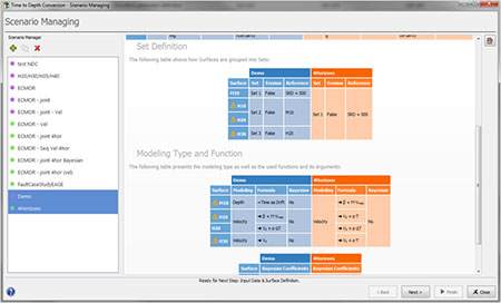
  • Choose to perform simultaneous conversion of several conformable horizons (innovative joint approach unique to Isatis.neo minimizing error propagation) or a sequential one (conversion layer by layer).
  • Consider or not to integrate a fault model in the process. Input fault data can be in depth or in time. In that case, faults will be converted in the conversion process.
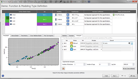
  • Achieve depth conversion through ordinary kriging with or without an external drift, in a classical or a Bayesian approach. Reach the best results by choosing to perform this with depth modeling or velocity modeling, defining which formula to use or inputting your own velocity map model as a trend.

Consider multiple sources of uncertainty

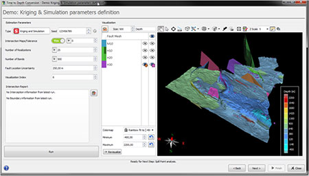
  • Benefit from the only conversion tool in the market that manages uncertainties on fault locations. Quickly produce a fault mesh model from input fault sticks and consider a position uncertainty window in the conversion process.
  • Take into account different sources of uncertainty (time horizon, velocity, fault positions) in the calculations for the most comprehensive spill point characterization, trap analysis and volume analysis.
  • Test pessimistic, most likely and optimistic scenarios in volumetrics.

Be sure of the estimate quality

  • Reduce misties at locations where two or more measures are recorded before any further calculation. Estimation and uncertainty maps are delivered (to be released in early 2020).
  • Quickly verify the expected quality of the conversion through cross-plots and several powerful statistics and fine tune parameter values.
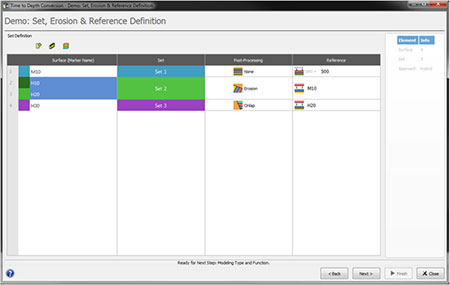
  • Be sure that converted surfaces do not overlap each other by running specific post-processing ensuring geology compliant surfaces. Two types of situations are currently supported: erosion and onlap. Intersection and probability maps are delivered.

Achieve uncertainty analysis on traps and spil-points

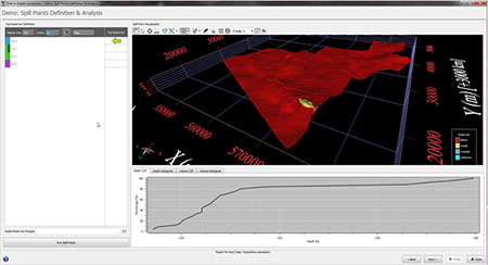
  • Benefit from an automatic determination of traps and associated spill points for each depth realization.
  • Get the probability map to be inside or below the trap, the distribution curve and the histogram of spill point depths and trap volumes.

Perform the most comprehensive risk analysis on volumes

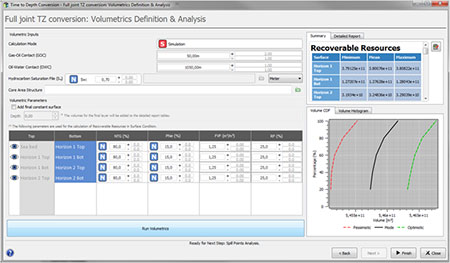
  • Get pessimistic, most likely and optimistic scenarios of various volumes (recoverable resources, oil zone, gas zone and above spill points volumes) considering fluid contacts and dynamic reservoir information (porosity, hydrocarbon saturation, Formation Volume Factor, Recovery Factor and Net to Gross ratio) and their pessimistic, mode and optimistic values

Wish to see the product live? Contact us to arrange a demo

Contact

info@geovariances.com
FRANCE
Tel +33 (0)1 6074 9090
AUSTRALIA
Tel +61(0)8 9321 3877
BRAZIL
Tel +55 31 3267 9095

ANY QUESTIONS ?

If you would like to discuss your needs or an upcoming project, please feel free to contact us by completing this form.

Fill the form

MEDIA

  • Newsletter subscription
  • Blog posts
  • Press releases
  • Press review

CONNECT WITH US

Find our Jobs
©2022 Geovariances — All rights reserved. Privacy Policy, terms & conditions
website 2.0.0-develop-598 (7be7bc43 on 2022-04-29 11:26:46+02:00), production build

Operation in progress, please wait...


We use cookies on this website to enhance your user experience.

By clicking I Accept, you are giving us your consent to deploy cookies under our Privacy and Cookies Policy.
By clicking No Thanks, you will continue with only the necessary cookies, essential for the proper functionning of your MY GEOVARIANCES account.

No thanks I accept

LOGIN TO OUR WEBSITE

Business Email *


Why be authenticated on our website?

• To have free access to your private space MY GEOVARIANCES for software and technical documentation download
• To benefit from free download of technical resources
• To fill any form without entering details again and again
• To register for a training course or a seminar in one mouse click

For any question, please contact webmaster@geovariances.com


Search

Registration status

Thank you very much for your request to participate in our event
We will get back to you shortly to confirm your registration.

In the meantime, why not access our resources to know more about our software solutions and expertise?

Access our online technical resources

Registration status

Thank you for registering for our webinar.
Watch your email box. You should have received an email with the link to access the webinar at the scheduled time.

In the mean time, why not access our technical resources to know more about our software solutions and expertise?

Visit our online Technical Resources page

Registration status

Thank you for your interest in our webinar.

You have already registered for this session.
Please note that you will receive reminder emails with the link to access the webinar one day and one hour before it starts.

In the mean time, why not access our technical resources to know more about our software solutions and expertise?

Visit our online Technical Resources page

YOU DON'T HAVE ACCESS TO THIS RESOURCE

You don't have permission to access the requested page or video or download the pdf.


Only Geovariances software users (commercial, academic, or trial licenses) can access this resource.

Permission also depends on the purchased/tried software.

Contact webmaster@geovariances.com for more info.

Stay current with our news

Get some tips on how to use our software solutions. Be the first to hear about software updates and new features, the publication of blog articles, white papers or client stories. Keep your agenda up to date with our training sessions, webinars, and workshops.

Subscribe now to our emails, newsletters, and/or blog.

> SUBSCRIBE

MAKE AN ENQUIRY

If you have questions or would like to discuss your needs or an upcoming project, please feel free to contact us by completing this form. We are happy to help.