Skip to content

THE GLOBAL PROVIDER OF GEOSTATISTICS-BASED SOLUTIONS

   Access our blog  |  Subscribe to our newsletters  |  Contact us
    MY GEOVARIANCES        LOG IN   
Logo Geovariances
  • Industries
    • Mining Industry
    • Oil & Gas Industry
    • Nuclear Decommissioning
    • Contaminated Sites
    • Air, water, soil, bioresources and other
  • Software
    • Isatis.neo, accessible powerful geostatistics
    • Kartotrak, for contaminated site characterization
    • On demand library and application development
    • Innovation
    • Technical support
  • Consulting
  • Training
    • Training offer
    • Upcoming training sessions
    • Training catalog
  • Resources
  • About
    • What our clients say about us
    • Who we are
    • News
    • Events
SUBSURFACE MODELING AND NATURAL HAZARD ASSESSMENT

Geostatistics allows getting relevant geological and groundwater models and assessing vulnerability to natural hazards. Modeling the subsurface is of increasing importance for numerous issues: geotechnical needs, groundwater modeling, water resource estimation, assessment of the vulnerability to natural hazards, etc..

Whatever your need is, geostatistics provides relevant methods to properly map your target variables and quantify the uncertainties related to their estimation.

HYDROGEOLOGY MAPPING

Ice content simulation

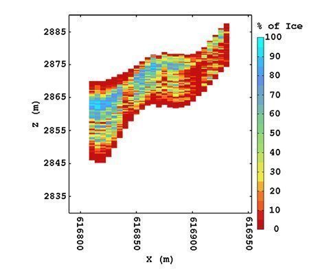
The geostatistical mapping algorithm, called kriging, is based on the specific behavior of the phenomenon via a spatial correlation function calculated from the sample measurements. Because this correlation function determines the shape of the final map, the geostatistical algorithm adapts itself directly to the spatial characteristics of your groundwater properties. Through the modeling of the spatial behavior, kriging enables to produce accurate maps together with their related uncertainties.

Key applications:

  • Monitoring network optimization to reduce maintenance costs without hampering the prediction quality.
  • Modeling of aquifer properties (i.e. permeability, porosity) and geometry, hydraulic heads.
  • Water pollution estimation, together with its uncertainty.


SAMPLING OPTIMIZATION

The probabilistic framework of geostatistics enables the calculation of different uncertainty indices such as the estimation variance or confidence intervals related to the estimate of the target variable. Therefore, it is possible to tune additional sample locations to reduce specific uncertainty criteria. In the case of the estimation variance, as this one only depends on the spatial structure and the data configuration, additional samples will be located in under-sampled areas. Points located to reduce confidence intervals around kriging estimates will be expected to be in areas with high variability.


NATURAL HAZARD ASSESSMENT

Geostatistics allows taking into account multiple data sources in order to quantify the vulnerability to natural hazards: flooding, soil and geotechnical stability, etc. It can be used to create facies models for the subsurface and populate them with geological properties in order to assess the soil stability.


COMMUNICATION MEDIA UPDATING

Because your data can be collected automatically at regular time intervals, it is possible to generate maps in real-time using Isatis scripting procedures. A set of calculations is stored, as well as the input data and parameters. The entire workflow is then replayed. This powerful tool can be used to produce updated maps for communication via the internet.


DISCOVER OUR SOFTWARE SOLUTIONS →
DISCOVER OUR CONSULTING SERVICES →

Contact

info@geovariances.com
FRANCE
Tel +33 (0)1 6074 9090
AUSTRALIA
Tel +61(0)8 9321 3877
BRAZIL
Tel +55 31 3267 9095

ANY QUESTIONS ?

If you would like to discuss your needs or an upcoming project, please feel free to contact us by completing this form.

Fill the form

MEDIA

  • Newsletter subscription
  • Blog posts
  • Press releases
  • Press review

CONNECT WITH US

Find our Jobs
©2022 Geovariances — All rights reserved. Privacy Policy, terms & conditions
website 2.0.0-develop-598 (7be7bc43 on 2022-04-29 11:26:46+02:00), production build

Operation in progress, please wait...


We use cookies on this website to enhance your user experience.

By clicking I Accept, you are giving us your consent to deploy cookies under our Privacy and Cookies Policy.
By clicking No Thanks, you will continue with only the necessary cookies, essential for the proper functionning of your MY GEOVARIANCES account.

No thanks I accept

LOGIN TO OUR WEBSITE

Business Email *


Why be authenticated on our website?

• To have free access to your private space MY GEOVARIANCES for software and technical documentation download
• To benefit from free download of technical resources
• To fill any form without entering details again and again
• To register for a training course or a seminar in one mouse click

For any question, please contact webmaster@geovariances.com


Search

Registration status

Thank you very much for your request to participate in our event
We will get back to you shortly to confirm your registration.

In the meantime, why not access our resources to know more about our software solutions and expertise?

Access our online technical resources

Registration status

Thank you for registering for our webinar.
Watch your email box. You should have received an email with the link to access the webinar at the scheduled time.

In the mean time, why not access our technical resources to know more about our software solutions and expertise?

Visit our online Technical Resources page

Registration status

Thank you for your interest in our webinar.

You have already registered for this session.
Please note that you will receive reminder emails with the link to access the webinar one day and one hour before it starts.

In the mean time, why not access our technical resources to know more about our software solutions and expertise?

Visit our online Technical Resources page

YOU DON'T HAVE ACCESS TO THIS RESOURCE

You don't have permission to access the requested page or video or download the pdf.


Only Geovariances software users (commercial, academic, or trial licenses) can access this resource.

Permission also depends on the purchased/tried software.

Contact webmaster@geovariances.com for more info.

Stay current with our news

Get some tips on how to use our software solutions. Be the first to hear about software updates and new features, the publication of blog articles, white papers or client stories. Keep your agenda up to date with our training sessions, webinars, and workshops.

Subscribe now to our emails, newsletters, and/or blog.

> SUBSCRIBE

MAKE AN ENQUIRY

If you have questions or would like to discuss your needs or an upcoming project, please feel free to contact us by completing this form. We are happy to help.