Geostatistics applies to spatial data acquired in almost every context: climatology, geochemistry, epidemiology, forestry, archaeology, etc.
Whatever the nature of your spatial data, geostatistics provide powerful and flexible solutions for data analysis, 2D/3D mapping and uncertainty assessment.
Geostatistics applied to mapping and uncertainty assessment of any spatial dataset
EXPLORATORY DATA ANALYSIS
Exploratory data analysis allows identifying and handling data anomalies and anisotropies using appropriate statistical representations: basemap, histogram, q-q plot, variogram map, logs, 3D viewer. The analysis of the spatial distribution of the variable of interest is based on a spatial correlation function calculated from the sample measurements and known as the variogram. The relationship between the variable and its environment may also be investigated in order to improve the understanding of its spatial dynamics.
MAPPING
The geostatistical mapping algorithm, called kriging, is based on the variogram computed beforehand. Because this correlation function determines the shape of the final map, the geostatistical algorithm adapts itself directly to the spatial characteristics of your target variable. Through the modeling of the spatial behavior, kriging provides you with accurate predictions at unsampled locations. In addition, kriging variants such as cokriging or external drift kriging give you the ability to integrate in the modeling additional variables that are correlated with your phenomenon of interest for refined models. Local Geostatistics also enables to account for spatially varying variogram features.
UNCERTAINTY ASSESSMENT
Geostatistics goes beyond interpolation and kriging, bringing you the solution to quantify the uncertainty associated to the prediction of your phenomenon. Stochastic simulations provide possible images of the target variable that honor data values and the spatial variability captured by the variogram. Such simulations allow you identifying areas exceeding thresholds of interest or estimating global quantities above such thresholds, together with their related uncertainties.
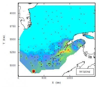
Daily precipitation mapping over Quebec
Kriging of daily precipitation over Quebec using local variogram parameters (Hydro-Quebec courtesy)
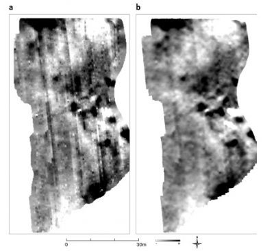
Improving magnetic survey outcomes for archeological prospection
Raw data (a) and factorial kriging result applied in order to remove acquisition artifacts (b) (Tamba, 2015, p. 43).