Skip to content

Geovariances is a Datamine company.    X

THE GLOBAL PROVIDER OF GEOSTATISTICS-BASED SOLUTIONS

   Access our blog  |  Subscribe to our newsletters  |  Contact us
    MY GEOVARIANCES        LOG IN   
Logo Geovariances
  • Industries
    • Mining Industry
    • Oil & Gas Industry
    • Nuclear Decommissioning
    • Contaminated Sites
    • Air, water, soil, bioresources and other
  • Software
    • Isatis.neo, accessible powerful geostatistics
    • Kartotrak, for contaminated site characterization
    • Isatis.py, Python package in geostatistics
    • On demand library and application development
    • Innovation
    • Technical support
  • Consulting
  • Training
    • Training offer
    • Upcoming training sessions
    • Training catalog
  • Resources
  • About us
    • What our clients say about us
    • Who we are
    • News
    • Events
DATA QUALITY CONTROL AND EXPLORATORY DATA ANALYSIS

Geostatistics gives you the tools for data quality control, helping you investigate, analyze, clean, and validate any geospatial dataset. Contamination data quality directly affects characterization reliability. A poor-quality data means an untrustworthy characterization and an increased risk of bad decision-making. It is why you must be sure of the quality of your data before using them.

Contamination data analysis

Visualize your data in its environmental context

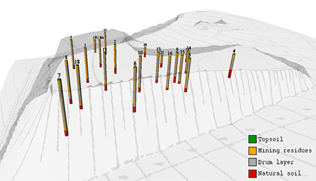
A first way of controlling data is to visualize them in 2D/3D. Qualitative and quantitative information (historical information, indirect measurements, aerial views, topography, geology, or physical models) may be gathered into a single view. It helps you gain a better understanding of the contamination history and evolution. Geovariances software Kartotrak has a specific feature that allows identifying GPS errors and correct data position. 3D data visualization and log display make it possible to navigate inside the data and search for anomalies.

Download our tech paper about Sampling Optimization for the Characterization of a Drum Disposal Legacy to find out more →
Contamination data analysis

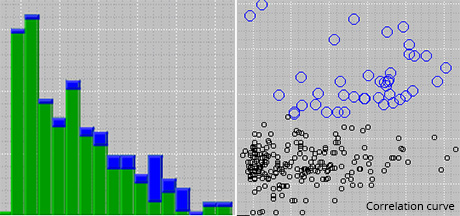
Explore and control data quality

Geostatistics offers powerful tools for exploratory data analysis and investigation. Thorough data analysis gives a better understanding of the nature of data and allows cross-checking different data acquisition campaigns. Conventional statistical tools, like histograms, q-q plots, correlation curves, are used for identifying data distribution, outliers, irregularities, and heterogeneities.

Download our white paper about Data Quality Control to learn more →
Data analysis for outlier identification

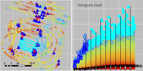
Check the spatial consistency

Combining geostatistical and statistical tools such as the variogram cloud and the base map is even more powerful to localize outliers and abnormal values. It easily puts into evidence points with significant variability in comparison to surrounding points.

Read more on variography analysis →

Use robust and innovative tools

Discover our software solution

Get trained in geostatistics

Discover our training offer

Benefit from our unique expertise

Discover our consulting services

Contact

info@geovariances.com
EUROPE, AFRICA, ASIA, OCEANIA
Tel +33 (0)1 6074 9090
NORTH AMERICA
Tel +1 437 432 3346
SOUTH AMERICA
Tel +55 11 98384 9716

ANY QUESTIONS ?

If you would like to discuss your needs or an upcoming project, please feel free to contact us by completing this form.

Fill the form

MEDIA

  • Newsletter subscription
  • Blog posts
  • Press releases
  • Press review

CONNECT WITH US

Find our Jobs
©2025 Geovariances — All rights reserved. Privacy Policy, terms & conditions
website v2.757-3424654-develop - 2024-08-28@17:49:08

Operation in progress, please wait...


We use cookies on this website to enhance your user experience.

By continuing to navigate on this site, you accept that we deploy the strictly necessary cookies for its proper functioning and measuring traffic.

Note that our videos are hosted by Youtube. By watching them, you accept the terms and conditions of www.youtube.com.
Read our Privacy and Cookies Policy.

Got it

LOGIN TO OUR WEBSITE

Business Email *


Why be authenticated on our website?

• To have free access to your private space MY GEOVARIANCES for software and technical documentation download
• To benefit from free download of technical resources
• To fill any form without entering details again and again
• To register for a training course or a seminar in one mouse click

For any question, please contact webmaster@geovariances.com


Stay current with our news

Get some tips on how to use our software solutions. Be the first to hear about software updates and new features, the publication of blog articles, white papers or client stories. Keep your agenda up to date with our training sessions, webinars, and workshops.

Subscribe now to our emails, newsletters, and/or blog.

> SUBSCRIBE

MAKE AN ENQUIRY

If you have questions or would like to discuss your needs or an upcoming project, please feel free to contact us by completing this form. We are happy to help.