Maxwell GeoSystems help their clients improve tunnels’ construction project performance with a new offer implementing geostatistics and Isatis.neo
Maxwell GeoSystems is a software company that develops a platform dedicated to construction data management, display, and interpretation. As a data specialist, Maxwell GeoSystems' mission is to give their clients the best interpretation of their data to reduce risk and improve construction performance. They recently integrated geostatistics with Isatis.neo in their modeling process to quantify and communicate the uncertainty of their interpretation for a greater understanding of the ground conditions.
Building a new offer with geostatistics…
Maxwell GeoSystems designs solutions to various challenges, among them the construction of tunnels. One of the big sources of risk in tunnel construction is the uncertainty and variability in the ground conditions. Current practice in the design of tunneling projects investigates the site, collects geological and geotechnical data, builds 2D geological cross-sections, and, more recently, 3D geological models. 3D models are attractive, with bright colors, look real but do not normally consider subsurface variability and uncertainty. When contractors have such deterministic models in hand, they assume they represent the actual ground conditions. They start the construction having planned the cutter tools to use, where and when they need to control their wear and change them.
3D deterministic models of ground conditions can result in the false assurance of how well the subsurface conditions are known, potentially resulting in losing time and money during construction.
Jacob Grasmick, Geotechnical Engineer at Maxwell GeoSystems, gives two examples of situations contractors may experience. “Suppose contractors decide to stop the excavation to inspect the cutter head and find that none of the tools are very worn. Or they realize they went too far and find that the cutter head is heavily damaged. Such situations make them waste substantial time and money. In these cases, they want to be compensated because they say the ground conditions encountered are different from what the deterministic models indicate.”
A solution to limit unnecessary or late interventions is to provide contractors with probabilistic models based on geostatistical outputs.
Geostatistics is used to model the spatial behavior of the geotechnical or geological parameters and populate unsampled locations. Geostatistical simulations based on probabilistic analyses provide an estimation of any parameter with spatial uncertainty quantification. Rather than putting a squiggly line with some question marks at a transition between two soil layers, it allows defining an uncertainty band with a minimum and a maximum value to be considered. “Geologists may supply any interpretated boundary line safe in the knowledge that it is as valid as interpretations. This relieves them of the responsibility if the subjective interpretation is wrong.” Jacob Grasmick says.
Probabilistic models allow a much more comprehensive representation and understanding of ground conditions, leading to a better rate of progress in tunnel construction.
Jacob Grasmick is convinced of the added value of geostatistics for the tunnel industry. During his PhD. at the Colorado School of Mines, he applied it to model the variability and uncertainty of ground geological/geotechnical conditions and assess how they impact the risk assessment and the mitigation planning for tunnel construction.
Furthermore, statistical confidence parameters from the modeling can be queried in real time by the tunnel boring machine and updated regularly as more data arrives, including feedback from the machine itself.
One of the uses he makes of geostatistics at Maxwell GeoSystems is to produce a probabilistic representation of the subsurface in terms of how it will impact the way of tool wear. Indeed, geostatistics can help characterize geotechnical risk through the extension from spatial uncertainty to tunneling risk.
“Having the most probable estimate with a confidence interval around it, contractors have a much more comprehensive representation and understanding of the ground conditions. They can make decisions proactively about when and where they want to carry out interventions,” he explains. “They can better convey and communicate their decisions. It is very much a mutual benefit for the owner and the contractor.”
Probabilistic models can change the way contractors will choose to build the job to ensure that the risk of failure is minimized. They can help them save a week on a project or hundreds of thousands of dollars.
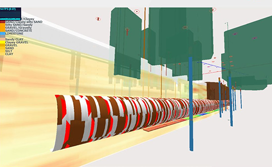
Example output of geotechnical parameter simulation for the assessment of mechanized tunneling risks such as cutter tool wear.
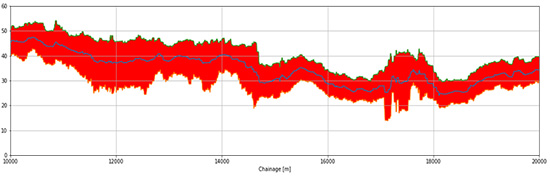
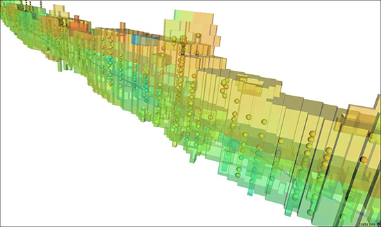
95% confidence interval of a geotechnical parameter within the tunnel horizon extracted from geostatistical simulations. This information can be used by tunnel boring machine (TBM) operators to make more informed decisions on mitigation strategies and TBM operating parameters.
The need for a specialized built-in geostatistics software solution…
Before making his choice on Isatis.neo, Jacob tested a couple other popular software products. He also tried to use some of the open-source options. “Isatis.neo is leaps and bounds beyond what the other ones provide.” he says. “Other packages come up with deterministic models but without the information about uncertainty needed for a true risk assessment. It was a pretty easy decision to make to deal with Isatis.neo.”
Jacob Grasmick selected Isatis.neo for its comprehensiveness, user-friendliness, and quickness and because it fulfills all his objectives.
Jacob Grasmick enjoys Isatis.neo for three key aspects. Its unmatched number of geostatistical tools, its user-friendly user interface, and its 3D visualization capabilities. “They are beyond the state of the art because they really give someone like me an easy way to quickly digesting the data. Tools are easy to find,” he explains. “I can import a data set easily and quickly begin to digest what the data is telling me. From an exploratory data perspective, even just from that aspect, it is extremely valuable.”
A tool of choice for Jacob, who qualifies it as a valuable tool for the tunnel industry, is the Plurigaussian Simulations used for facies modeling. One project Maxwell GeoSystems successfully achieved in that sense was a sewer tunnel construction project in the UK. Their client wanted to gain a better understanding of the marginal facies within the Mercia mudstone formation that create some challenges for groundwater control for tunneling. Maxwell runs geostatistical simulations to derive a better characterization of the subsurface focused on those challenges.
“I also like the Python calculator very much. It gives me the capability to achieve the post-processing that I need within Isatis.neo. I don’t have to export my data to other Python tools, making me lose precious time. I can translate the geotechnical model to engineering parameters relevant to specific risks, such as cutting tool wear. Even more, I can easily extract all the statistics I need.”
And Jacob adds that despite simulations could be time-consuming, especially for PCs low on memory, Isatis.neo is still the fastest solution.
Perspectives…
Today, there is a disbelief in the construction community that there is not enough data for a geostatistical interpretation. But geostatistics, in characterizing the subsurface variability, has undoubtedly a role to play, especially for urban projects with excavated stations beneath the high rise that require heavy investigation. But also for any earthwork structures, including slopes, foundations, or retaining walls.
“Isatis.neo is in line with the construction industry to adopt geostatistics. This is why I would recommend it without any doubt.”
“Another benefit of Isatis.neo is that you have a streamlined, automated way of updating your model as you get new data. That’s just an untapped opportunity for the industry to be able to update the model at the middle of the construction project.”
And Jacob to conclude: “Geostatistics is a relatively new world for the civil/geotechnical industry. I think that this has a lot to do with the lack of skill set. My objective is to make our community adopt the technique for more informed decisions.”