Skip to content

Geovariances is a Datamine company.    X

THE GLOBAL PROVIDER OF GEOSTATISTICS-BASED SOLUTIONS

   Access our blog  |  Subscribe to our newsletters  |  Contact us
    MY GEOVARIANCES        LOG IN   
Logo Geovariances
  • Industries
    • Mining Industry
    • Oil & Gas Industry
    • Nuclear Decommissioning
    • Contaminated Sites
    • Air, water, soil, bioresources and other
  • Software
    • Isatis.neo, accessible powerful geostatistics
    • Kartotrak, for contaminated site characterization
    • Isatis.py, Python package in geostatistics
    • On demand library and application development
    • Innovation
    • Technical support
  • Consulting
  • Training
    • Training offer
    • Upcoming training sessions
    • Training catalog
  • Resources
  • About us
    • What our clients say about us
    • Who we are
    • News
    • Events
WHAT'S NEW IN ISATIS.NEO v1.1?

When developing Isatis.neo, we’ve got one goal in mind, that our new software solution integrates all your favorite Isatis tools as quickly as possible. Isatis.neo v1.1 progresses towards this objective by providing new functionalities for data management, analysis, estimation, and simulation.

New features and improvements common to all editions

Project and variable management

  • Quickly transfer your Isatis study to Isatis.neo through a new plugin.
  • You’ve been asking for the Macro Variables. We’ve integrated them into Isatis.neo.
  • Store rotation and gradient information into new Vector objects that will be used in kriging with the option Use Local Anisotropies or the definition of sub-blocks.

Data analysis

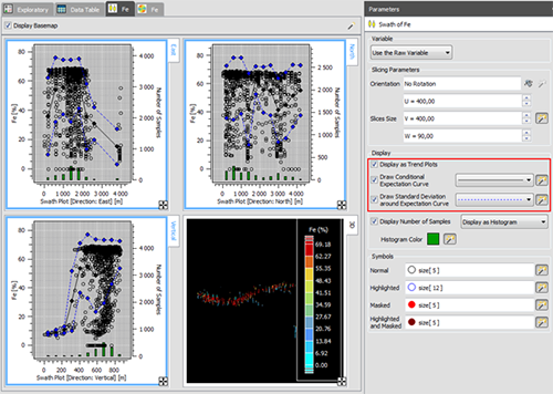
  • Analyze further your data with the new Trend plots.
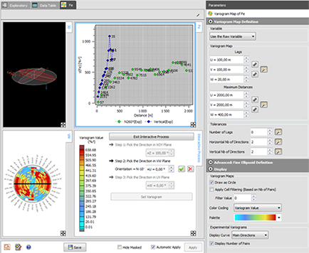
  • Identify and handle anisotropies from the interactive variogram map.
  • Run connectivity analysis on grids and identify connected components. This can be used to locate permeable pathways inside a lithostratigraphic unit.
  • Compute downhole variograms.
  • Generate local anisotropy directions at any node of a grid file considering they are parallel to a reference surface or guided by a top and a bottom surface.
  • Remove imperfections in images by running morphological operations on grids.
  • Perform sample clustering using a powerful machine-learning algorithm.

Data display

  • The Clipping tool has been improved.


Standard Edition

Data exchange

  • Import data from the acQuire database to create or append some drill holes to Isatis.neo.
  • Import Datamine sub-block models and drill holes.

Data analysis

  • Prepare your data to block kriging. Compute a support correction considering or not the Information Effect. Derive the grade-tonnage curves of mineral resources from the anamorphosis function.

Wireframe/domain modeling

  • Generate the envelope of each facies class or mining domain identified through a previous sample clustering or from any categorical variables.
  • Get the probability to be inside a wireframe. Compute the volume distribution curve and class uncertainty.

Estimation

  • Assess recoverable mineral resources through Uniform Conditioning. Localize estimates computed on blocks to SMU.

Simulations

  • Save time and disk space with the Direct Block Simulations, a unique and powerful algorithm enabling to bypass point scale models to build block scale models directly.

Petroleum Edition

Easily exchange data with Petrel® through a dedicated plug-in.

Mining Edition

Find out more about the 1st version of Isatis.neo Mining Edition here.

Download Isatis.neo v1.1 Release Notes for the complete list of improvements

Contact

info@geovariances.com
EUROPE, AFRICA, ASIA, OCEANIA
Tel +33 (0)1 6074 9090
NORTH AMERICA
Tel +1 437 432 3346
SOUTH AMERICA
Tel +55 11 98384 9716

ANY QUESTIONS ?

If you would like to discuss your needs or an upcoming project, please feel free to contact us by completing this form.

Fill the form

MEDIA

  • Newsletter subscription
  • Blog posts
  • Press releases
  • Press review

CONNECT WITH US

Find our Jobs
©2025 Geovariances — All rights reserved. Privacy Policy, terms & conditions
website v2.757-3424654-develop - 2024-08-28@17:49:08

Operation in progress, please wait...


We use cookies on this website to enhance your user experience.

By continuing to navigate on this site, you accept that we deploy the strictly necessary cookies for its proper functioning and measuring traffic.

Note that our videos are hosted by Youtube. By watching them, you accept the terms and conditions of www.youtube.com.
Read our Privacy and Cookies Policy.

Got it

LOGIN TO OUR WEBSITE

Business Email *


Why be authenticated on our website?

• To have free access to your private space MY GEOVARIANCES for software and technical documentation download
• To benefit from free download of technical resources
• To fill any form without entering details again and again
• To register for a training course or a seminar in one mouse click

For any question, please contact webmaster@geovariances.com


Stay current with our news

Get some tips on how to use our software solutions. Be the first to hear about software updates and new features, the publication of blog articles, white papers or client stories. Keep your agenda up to date with our training sessions, webinars, and workshops.

Subscribe now to our emails, newsletters, and/or blog.

> SUBSCRIBE

MAKE AN ENQUIRY

If you have questions or would like to discuss your needs or an upcoming project, please feel free to contact us by completing this form. We are happy to help.