Skip to content

Geovariances is a Datamine company.    X

THE GLOBAL PROVIDER OF GEOSTATISTICS-BASED SOLUTIONS

   Access our blog  |  Subscribe to our newsletters  |  Contact us
    MY GEOVARIANCES        LOG IN   
Logo Geovariances
  • Industries
    • Mining Industry
    • Oil & Gas Industry
    • Nuclear Decommissioning
    • Contaminated Sites
    • Air, water, soil, bioresources and other
  • Software
    • Isatis.neo, accessible powerful geostatistics
    • Kartotrak, for contaminated site characterization
    • Isatis.py, Python package in geostatistics
    • On demand library and application development
    • Innovation
    • Technical support
  • Consulting
  • Training
    • Training offer
    • Upcoming training sessions
    • Training catalog
  • Resources
  • About us
    • What our clients say about us
    • Who we are
    • News
    • Events
CONTAMINATION MAPPING

Geostatistics provides suitable methods that allow you to integrate all acquired data to predict activity concentration levels at unsampled locations. In addition to such contamination mapping, quantifying the uncertainty related to the estimates will help you anticipate potential risks or discoveries that may occur during remediation.

Geostatistics for radiation mapping

Deliver robust radiation maps

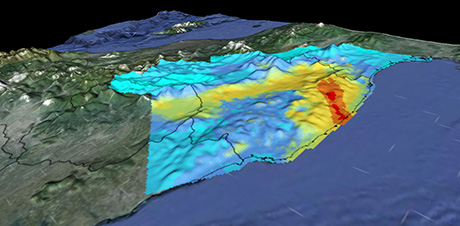
Kriging is a well-known and robust technique used in geostatistics to interpolate and predict values from a set of measurements combined with the variogram model. The main result is the generation of 2D and 3D contamination maps. The kriged map is associated with a variance map, which quantifies the uncertainty related to the estimation. It depends on the distance of an interpolated point from the observation point, sampled or measured, and the spatial structure thanks to the variogram model.

– Download our white paper about Dose Rate Mapping to learn more →
– Watch our video about the mapping of Fukushima contaminated area with Kartotrak”→

Geostatistics for radiation mapping

Benefit from all available information

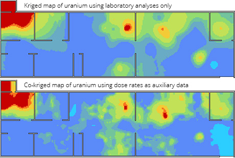
When different types of measurements or various contaminants are available, multivariate geostatistics (or cokriging algorithms) may be used to reduce estimation uncertainty and improve map quality. The technique takes advantage of the correlation between contamination and environment variables (e.g., between activity levels and a Digital Elevation Model, for example). It beneficially integrates auxiliary data, which is more abundant in space, like dose rates (or any in situ measurement), in comparison to lab analyses on destructive samples, to produce maps with more spatial details. Multivariate analysis is also interesting from a financial viewpoint since the auxiliary datasets are less expensive and quicker to collect, or even sometimes already existing in the archives/records.

Geostatistics for contamination mapping and risk analysis

Inform your decisions with comprehensive uncertainty analysis

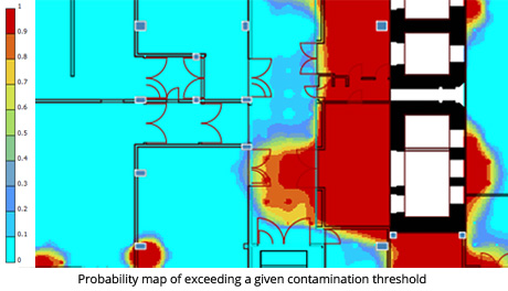
More advanced and sophisticated geostatistical methods, such as conditional expectation or geostatistical simulations, can be used to quantify different uncertainties – the risk of exceeding a threshold, for instance. These estimates are powerful decision-making aids when classifying surfaces and volumes before decontamination begins (based on different radioactivity thresholds and risk levels and considering the remediation support impact).

– Read more on waste classification →
– Download our article about radiological characterization for decommissioning a nuclear facility to find out more →

Use robust and innovative tools

Discover our software solution

Get trained in geostatistics

Discover our training offer

Benefit from our unique expertise

Discover our consulting services

Contact

info@geovariances.com
EUROPE, AFRICA, ASIA, OCEANIA
Tel +33 (0)1 6074 9090
NORTH AMERICA
Tel +1 437 432 3346
SOUTH AMERICA
Tel +55 11 98384 9716

ANY QUESTIONS ?

If you would like to discuss your needs or an upcoming project, please feel free to contact us by completing this form.

Fill the form

MEDIA

  • Newsletter subscription
  • Blog posts
  • Press releases
  • Press review

CONNECT WITH US

Find our Jobs
©2025 Geovariances — All rights reserved. Privacy Policy, terms & conditions
website v2.757-3424654-develop - 2024-08-28@17:49:08

Operation in progress, please wait...


We use cookies on this website to enhance your user experience.

By continuing to navigate on this site, you accept that we deploy the strictly necessary cookies for its proper functioning and measuring traffic.

Note that our videos are hosted by Youtube. By watching them, you accept the terms and conditions of www.youtube.com.
Read our Privacy and Cookies Policy.

Got it

LOGIN TO OUR WEBSITE

Business Email *


Why be authenticated on our website?

• To have free access to your private space MY GEOVARIANCES for software and technical documentation download
• To benefit from free download of technical resources
• To fill any form without entering details again and again
• To register for a training course or a seminar in one mouse click

For any question, please contact webmaster@geovariances.com


Stay current with our news

Get some tips on how to use our software solutions. Be the first to hear about software updates and new features, the publication of blog articles, white papers or client stories. Keep your agenda up to date with our training sessions, webinars, and workshops.

Subscribe now to our emails, newsletters, and/or blog.

> SUBSCRIBE

MAKE AN ENQUIRY

If you have questions or would like to discuss your needs or an upcoming project, please feel free to contact us by completing this form. We are happy to help.