Skip to content

Geovariances is a Datamine company.    X

THE GLOBAL PROVIDER OF GEOSTATISTICS-BASED SOLUTIONS

   Access our blog  |  Subscribe to our newsletters  |  Contact us
    MY GEOVARIANCES        LOG IN   
Logo Geovariances
  • Industries
    • Mining Industry
    • Oil & Gas Industry
    • Nuclear Decommissioning
    • Contaminated Sites
    • Air, water, soil, bioresources and other
  • Software
    • Isatis.neo, accessible powerful geostatistics
    • Kartotrak, for contaminated site characterization
    • Isatis.py, Python package in geostatistics
    • On demand library and application development
    • Innovation
    • Technical support
  • Consulting
  • Training
    • Training offer
    • Upcoming training sessions
    • Training catalog
  • Resources
  • About us
    • What our clients say about us
    • Who we are
    • News
    • Events
VARIOGRAPHY ANALYSIS

Variography analysis is the core of geostatistics. The accuracy of a geostatistical characterization depends strongly on the representativeness of the variogram model. Variography analysis also helps in designing a consistent interpolation process.

Geostatistics for the characterization of nuclear facilities, sites and waste

Understand and model the spatial behavior of the contaminants

Geostatistics, beyond conventional statistical analyses, allows studying data spatial variability. This is performed through the variogram which measures how dissimilar the neighboring data are. More specifically, it quantifies how much the contamination level measured on two samples varies depending on the distance between the samples. The variogram is a function that is required for the geostatistical interpolation process.

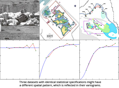
From no spatial structure (pure nugget effect) as it is generally found with heterogeneous wastes in trenches (as on the left side of the picture), to very continuous contamination in groundwater plume (as on the right side of the picture), with contamination of soils and concrete in between, the variogram reveals and models the spatial correlation of the phenomenon.

The spatial structure is crucial for the overall geostatistical approach and strongly impact sampling strategies.

Break down the different variability contributions

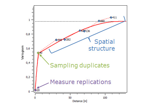
The variogram quantifies the variability at any scale. Thus the spatial structure can be directly compared to :
– the variance of sample duplicates, which can be significant if the sampling protocol is not relevant;
– the variance of measurement replications, which is generally negligible.

In addition, coordinate errors (with poor GPS accuracy for example) can artificially generate a nugget effect and therefore compress the real spatial structure of the phenomenon.

Not to mention the impact of data support (punctual value in comparison to average value on a given surface or mass) impacts the variogram behavior at very small scales and can be analyzed separately.

Use robust and innovative tools

Discover our software solution

Get trained in geostatistics

Discover our training offer

Benefit from our unique expertise

Discover our consulting services

Contact

info@geovariances.com
EUROPE, AFRICA, ASIA, OCEANIA
Tel +33 (0)1 6074 9090
NORTH AMERICA
Tel +1 437 432 3346
SOUTH AMERICA
Tel +55 11 98384 9716

ANY QUESTIONS ?

If you would like to discuss your needs or an upcoming project, please feel free to contact us by completing this form.

Fill the form

MEDIA

  • Newsletter subscription
  • Blog posts
  • Press releases
  • Press review

CONNECT WITH US

Find our Jobs
©2025 Geovariances — All rights reserved. Privacy Policy, terms & conditions
website v2.757-3424654-develop - 2024-08-28@17:49:08

Operation in progress, please wait...


We use cookies on this website to enhance your user experience.

By continuing to navigate on this site, you accept that we deploy the strictly necessary cookies for its proper functioning and measuring traffic.

Note that our videos are hosted by Youtube. By watching them, you accept the terms and conditions of www.youtube.com.
Read our Privacy and Cookies Policy.

Got it

LOGIN TO OUR WEBSITE

Business Email *


Why be authenticated on our website?

• To have free access to your private space MY GEOVARIANCES for software and technical documentation download
• To benefit from free download of technical resources
• To fill any form without entering details again and again
• To register for a training course or a seminar in one mouse click

For any question, please contact webmaster@geovariances.com


Stay current with our news

Get some tips on how to use our software solutions. Be the first to hear about software updates and new features, the publication of blog articles, white papers or client stories. Keep your agenda up to date with our training sessions, webinars, and workshops.

Subscribe now to our emails, newsletters, and/or blog.

> SUBSCRIBE

MAKE AN ENQUIRY

If you have questions or would like to discuss your needs or an upcoming project, please feel free to contact us by completing this form. We are happy to help.