Skip to content

Geovariances is a Datamine company.    X

THE GLOBAL PROVIDER OF GEOSTATISTICS-BASED SOLUTIONS

   Access our blog  |  Subscribe to our newsletters  |  Contact us
    MY GEOVARIANCES        LOG IN   
Logo Geovariances
  • Industries
    • Mining Industry
    • Oil & Gas Industry
    • Nuclear Decommissioning
    • Contaminated Sites
    • Air, water, soil, bioresources and other
  • Software
    • Isatis.neo, accessible powerful geostatistics
    • Kartotrak, for contaminated site characterization
    • Isatis.py, Python package in geostatistics
    • On demand library and application development
    • Innovation
    • Technical support
  • Consulting
  • Training
    • Training offer
    • Upcoming training sessions
    • Training catalog
  • Resources
  • About us
    • What our clients say about us
    • Who we are
    • News
    • Events
SAMPLING STRATEGY DEFINITION

What sampling strategy to adopt for a reliable contamination characterization? How many samples or measurements are needed? Where to locate the measuring points? How to decide on the sampling pattern and spacing? Geostatistics answers all these questions. It provides the tools to design an optimized sampling campaign for each stage of a characterization project.

Sampling strategy for radioactive contamination characterization

Optimize the sampling design for the preliminary characterization

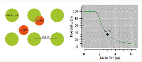
For this reconnaissance phase, geostatistics helps in setting a first investigation mesh based on the target dimension and expected spatial variability of the contamination level (which is assessed through a variographic analysis). A first 2D mapping is then delivered through kriging, which has the key advantage of providing information on the map quality (through the variance of kriging or other uncertainty indicators).

Sampling strategy for a reliable contamination characterization

Develop the sampling design for the destructive sampling phase

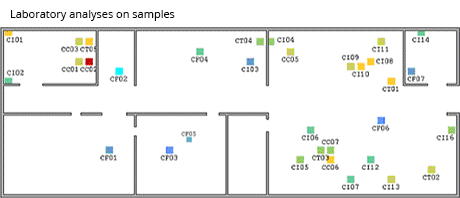
In this phase, precise estimation, inventory, and geometry assessment of the contaminated volumes are required. An ad hoc in-depth sampling is necessary to meet the characterization’s quality objectives. The design of this second sampling program benefits from the information acquired during the reconnaissance stage where a first radiation mapping was performed. The approach uses, in particular, the correlation between 2D dose rate and in-depth activity concentration on samples.

Watch the video to find out more →
Sampling strategy for a reliable contamination characterization

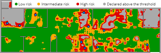
Refine the sampling effort for the complementary characterization

An additional sampling campaign may be needed to improve the delineation of the contaminated area and characterization quality. The previous geostatistics analysis benefits to the preparation of this additional campaign. It gives you the keys to identify areas where the uncertainty or the variability of the contamination level is the most important and to quantify and locate the extra measurement points that are needed. So, you improve your contamination characterization by reducing estimation uncertainties in an efficient way. From there, you can then assess the volume of each class of waste.

Use robust and innovative tools

Discover our software solution

Get trained in geostatistics

Discover our training offer

Benefit from our unique expertise

Discover our consulting services

Contact

info@geovariances.com
EUROPE, AFRICA, ASIA, OCEANIA
Tel +33 (0)1 6074 9090
NORTH AMERICA
Tel +1 437 432 3346
SOUTH AMERICA
Tel +55 11 98384 9716

ANY QUESTIONS ?

If you would like to discuss your needs or an upcoming project, please feel free to contact us by completing this form.

Fill the form

MEDIA

  • Newsletter subscription
  • Blog posts
  • Press releases
  • Press review

CONNECT WITH US

Find our Jobs
©2025 Geovariances — All rights reserved. Privacy Policy, terms & conditions
website v2.757-3424654-develop - 2024-08-28@17:49:08

Operation in progress, please wait...


We use cookies on this website to enhance your user experience.

By continuing to navigate on this site, you accept that we deploy the strictly necessary cookies for its proper functioning and measuring traffic.

Note that our videos are hosted by Youtube. By watching them, you accept the terms and conditions of www.youtube.com.
Read our Privacy and Cookies Policy.

Got it

LOGIN TO OUR WEBSITE

Business Email *


Why be authenticated on our website?

• To have free access to your private space MY GEOVARIANCES for software and technical documentation download
• To benefit from free download of technical resources
• To fill any form without entering details again and again
• To register for a training course or a seminar in one mouse click

For any question, please contact webmaster@geovariances.com


Stay current with our news

Get some tips on how to use our software solutions. Be the first to hear about software updates and new features, the publication of blog articles, white papers or client stories. Keep your agenda up to date with our training sessions, webinars, and workshops.

Subscribe now to our emails, newsletters, and/or blog.

> SUBSCRIBE

MAKE AN ENQUIRY

If you have questions or would like to discuss your needs or an upcoming project, please feel free to contact us by completing this form. We are happy to help.