What if geostatistics made the geotechnical engineer’s job easier?
To test the relevance of the geostatistical approach in the field of geotechnics, Eiffage Génie Civil Marine, a specialist in the construction of major port and maritime projects, asked Geovariances to produce a subsurface model for an existing project to compare with the model generated using their usual tools. The results proved more than convincing. Geostatistics allowed obtaining a model entirely consistent with the geotechnical model initially designed, in much less time. The method is justifiable, based on a scientific approach using all available data.
To date, geostatistics has been little used in the geotechnical sector. However, there is every reason for the profession to pay attention to it, as it allows modeling the subsoil by interpolating available data quickly and objectively while relying on mathematics that has been tried and tested for over 50 years. It could be the tool of choice for geotechnical engineers who have to interpret large quantities of data of all kinds and, above all, help them to justify and secure their designs.
Geostatistics has been used in the mining sector since the 50s to assess the mineral resources of a deposit. It has also long been used to characterize petroleum reservoirs, aquifers, or waste or gas storage units.
What can it bring to the field of geotechnical modeling?
This was the question asked of us by Eiffage Génie Civil Marine, a company specializing in constructing major port and maritime projects in France and abroad.
To provide an initial answer, Yves Puzenat and Mathieu Steckler, two geotechnical engineers from Eiffage Génie Civil Marine’s Technical Department, asked Geovariances to build a geostatistical model of the subsoil using geotechnical data from an existing project and then to deduce the pile lengths required for its foundation. The results would then be compared with the dimensioning already carried out during this project.
To do this, they provided Geovariances with the geological and geotechnical data measured in some fifty boreholes, which they used to build their geotechnical model of the project.
The first step was to model the subsurface geology in 3D (fig. 1) using Plurigaussian simulations, a geostatistical technique that enables precise control of the relationships and boundaries between facies using an assemblage rule (fig. 2) and a lithotype proportion matrix (fig. 3), calculated from borehole data.
“We saw that with the geostatistical approach, we had a picture quite similar to the one we had obtained with a conventional approach. It was an exciting first step”.
Yves Puzenat.
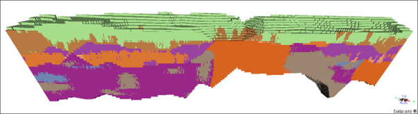
Fig. 1 : Geology interpolated using the geostatistical technique of plurigaussian simulations.
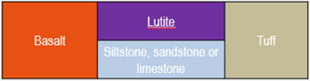
Fig. 2 : Example of a lithotype assemblage rule for plurigaussian simulations
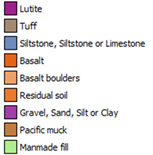
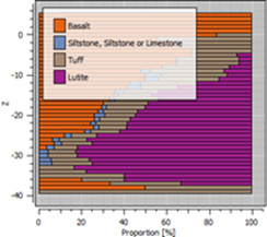
Fig. 3 : Example of a matrix of lithotype proportions as a function of depth
The second step focused on kriging interpolation of simple compressive strength measurements within the bedrock where the piles will be anchored. To account for the particular spatial behavior of this rock type-dependent parameter, interpolation was carried out independently for each geological facies: basalt, tuff, and lutite (fig. 4).
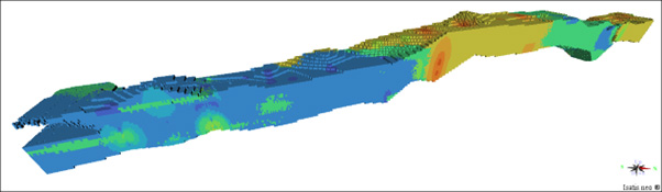
Fig. 4: Kriging interpolation of simple compressive strength measurements in bedrock.
Finally, the last step was to calculate the length of each pile from the results of step 1 (position of bedrock top) and step 2 (distribution of simple compressive strengths in bedrock), using the same pile calculation method as for the project. The resulting pile lengths could be compared with those initially calculated (fig. 5).
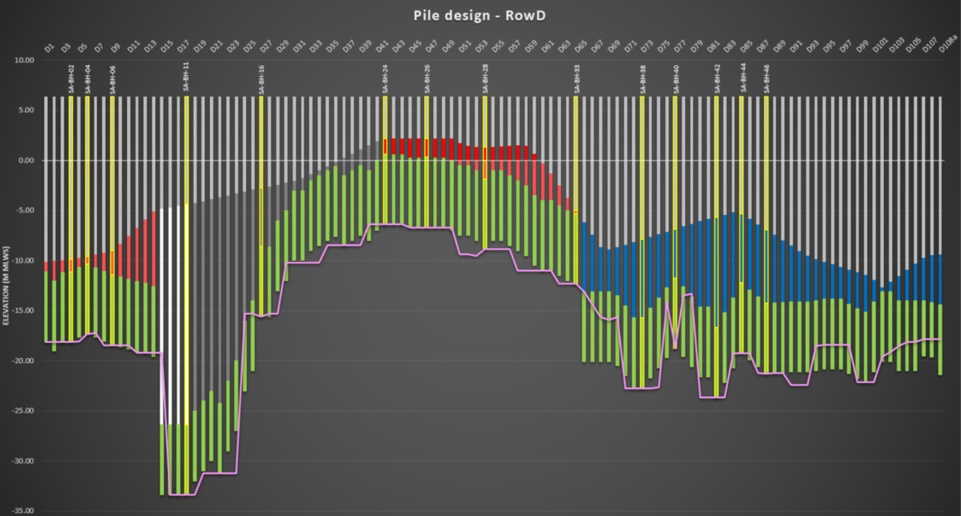
Fig. 5: Comparison, on a cross-section, of the geostatistical pile length, with calibration at each borehole (curve in pink), with that calculated by Eiffage Génie Civil Marine.
The pile lengths estimated using the geostatistical approach are similar to those initially calculated.
In this case, the cumulative pile length obtained by the geostatistical study is 3% less than the initial calculation.
The geostatistical study has helped optimize pile lengths. As the example shows, this can lead to significant savings on the “Foundations” cost line, which is always welcome.
“The results were obtained much more quickly than with the conventional method. We were impressed. In this example, we could have reduced the average length of the piles from 0.5 to 1 m.”
Mathieu Steckler.
This first test showed that geostatistics has its place in geotechnical engineering.
It allows rapid delivery of a model of the subsoil, entirely consistent with the geotechnical model initially designed. Today, the design of geotechnical models remains empirical and highly dependent on the engineer’s experience and habits. With geostatistics, the model is based on a recognized scientific approach and available data. The geotechnical engineers then have the necessary arguments to justify their decisions.
Nevertheless, geostatistics requires enough data (boreholes, tests) to be relevant. Here, with over 50 boreholes and all the results of mechanical laboratory tests on rock samples, the database used for the analysis is considered satisfactory. This is only sometimes the case in the geotechnical world.
Maxwell GeoSystems, an American engineering firm specializing in tunnel design and a Geovariances customer, goes further. In their view, it is essential to consider the uncertainty and variability of ground conditions to reduce hazards on site. They use geostatistical simulations, another facet of geostatistics, to provide probabilistic subsurface models. Instead of defining a single interface as the transition between two soil layers, they define an uncertainty band or confidence interval with a minimum and maximum value to be considered (fig. 6). Simulations applied to geotechnical parameters enable them to deduce a probabilistic representation of the subsoil in terms of its impact on Tunnel Boring Machine (TBM) wear. This helps the company to make proactive decisions when piloting the TBM. In this way, they can save time on project execution, leading to potentially significant savings.
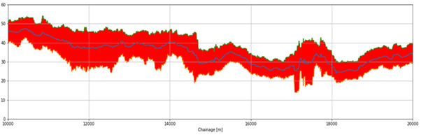
Fig. 6: 95% confidence interval of a geotechnical parameter in the tunnel horizon derived from geostatistical simulations. Tunnel Boring Machine (TBM) operators can use this information to make more informed decisions on mitigation strategies and TBM operating parameters (courtesy Maxwell Geosystems).
“I’m convinced that geostatistics is a considerable asset and has its place in the future of our profession.”
Mathieu Steckler
In the example presented here, Geovariances has applied these same geostatistical simulations to bedrock depth to produce risk analysis maps (quartiles). These maps, which define different depth scenarios depending on the risk tolerance on the estimated bedrock position, can eventually be used to define different pile length scenarios and thus budget for these scenarios.
To deal with the hazards naturally present in soils, it’s possible to imagine that this notion of risk could one day be included in standards, as is done, for example, when it comes to taking seismic risks into account in the design of structures. Based on the information available, defining a probability of encountering the interface between two formations at a given depth makes sense. Quantifying the associated risk would facilitate decision-making and represent a breakthrough for geotechnical engineering.