We have continued to implement the geostatistical techniques that were available in Isatis. In particular, we have added the Plurigaussian Simulations for facies modeling and developed further a kriging option allowing efficient mineral resource classification.
New features and improvements common to all editions
 Produce detailed and geologically sound facies models using the Plurigaussian Simulations (PGS) technique. The PGS implementation is the major novelty of the version 2020.06 of Isatis.neo. PGS are specifically designed to model complex geology with different structure orientations and heterogeneous deposits (channels, reefs, bars, differently oriented facies, sets of conjugate veins, or ore types where geological constraints apply). The technique helps you control the facies relationships and boundaries and provide realistic and detailed images of internal structures. The strength of this specific implementation is that it can perform the inference of the lithotype rule and underlying gaussian models in an automatic way. The lithotype rule can also be defined interactively using a flag graphical representation of lithotype contacts. Facies proportions may be constant or variable over the studied area.
- Flatten folded geological structures by vertical data translation (Projection mode) or by a translation normal to a reference level (Bend mode). The reference level can be a surface, or the top, bottom or medium level of a block model. The process allows aligning the grades measured along the same stratigraphic level and improves the quality of the variographic analysis and estimates.
- Compute and model correlograms.
- Compute the minimum distance between data (grid nodes, sample points, borehole samples) and a mesh and store results in a variable.
- Combine data from several files and merge them into a new file. You can either merge point data into a new point file (selecting or not the variables to retain) or borehole data into a new borehole file.
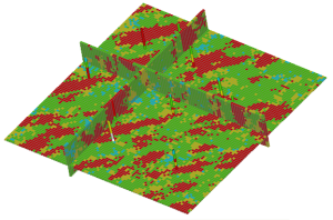
- Drape 2D images onto a surface in the 3D viewer.
Standard and Mining editions
- Produce Grade Tonnage Curves (that is tonnage, metal quantity, mean grade, and conventional benefit, above chosen grade cutoffs) from various data (grade estimates, tonnage and metal quantity as may be calculated by Uniform Conditioning or MIK, anamorphosis function), for the whole orebody or a given area or domain.
- Get a quick and robust classification of resources. The kriging option Use Sampling Density Variance delivers new variables that are used for resource classification. This original classification methodology developed in partnership with the Center of Geostatistics from MINES ParisTech has several advantages. It provides a robust and coherent classification index independent from the number of samples, the block size, and the domain extension. It integrates uncertainties related to the sampling mesh and spatial variability. And lastly, it facilitates the comparison of different deposits. The technique requires the definition of a production volume corresponding to a specific production period and a mean grade. Click for more info on the methodology.
Standard and Petroleum editions
- Load seismic 2D lines or 3D cubes stored in SEG-Y files. Data will be stored as 3D vertical pseudo wells and 3D grids.
Early-access menu
The Early Access menu gives you access to functionalities, the interfaces of which are not optimized. It offers advanced users the opportunity to test them and give their feedback.
Here are the functionalities that will be released in the next version and that you may already test:
- [Standard and Mining Editions] Estimation Validation lets you control the quality of your estimates through various statistics: histograms, swath plots, and cross plots between data and estimates.
- [Standard and Mining Editions] A separate post-processing tool Localized UC comes in addition (and is equivalent) to the Localized Uniform Conditioning option already available in the Uniform Conditioning functionality. You may use it to process Multiple Indicator Kriging (MIK) outputs to localize resources on SMU blocks. Download our white paper for more info on the Localized Uniform Conditioning (LUC) methodology.
- [Petroleum Edition] The Conversions & Uncertainties Workflow enables the export of time-to-depth conversion results into a velocity cube defined in depth.