How confident are you with your management plan quality?
Posted on The Kartotrak Excavation task allows generating excavation plans easily and fastly from 3D interpolated contamination maps. And it is only available in Kartotrak!
Kartotrak provides a sound and objective base to generate accurate excavation plans, letting you compare the efficiency of different remediation scenarios, thus paving the way to much better remediation management.
Once displayed, maps can be interactively refined for adapting them to remediation constraints. Hence, you can decide to leave in place one or several isolated blocks or to include non-contaminated blocks in the estimated volume to be excavated to facilitate remediation. You just have to increase or decrease the excavation depth using the mouse.
Using Kartotrak, you immediately know if your excavation plan is effective. The new tool computes and displays the total volume and total surface of the soil to be excavated. It also displays the efficiency of the remediation. Hence, you can easily conduct a sensibility study of the excavation plan efficiency according to your remediation strategy.
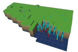
At last, the excavation limit surface may be displayed in 3D for quick viewing of the remediation global impact.
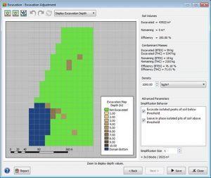
Kartotrak computes excavation maps from analytical results or 3D interpolated contamination maps
Mining (14)
Nuclear Decommissioning (9)
Contaminated sites (7)
Oil & Gas (6)
Hydrogeology (5)
TAGS:
2D/3D (2)
Background images (1)
Big data (1)
Conditional simulations (7)
Contaminated sites (2)
Contamination (2)
Drill Hole Spacing Analysis DHSA (3)
Excavation (2)
Facies modeling (2)
Flow modeling (1)
Geological modeling (3)
Gestion des sites pollués (2)
H2020 INSIDER (1)
Horizon mapping (1)
Ice content evaluation (1)
Isatis (11)
Isatis.neo (16)
Kartotrak (8)
Machine Learning (2)
Mapping (3)
MIK (2)
Mineral resource estimation (7)
Monitoring network optimization (1)
MPS (2)
Ore Control (1)
Pareto (2)
Pollution (2)
Post-accidental situation (2)
Recoverable resource estimation (3)
Resource classification (2)
Resources workflow (1)
Resource workflow (3)
Risk analysis (3)
Sample clustering (1)
Sampling optimization (3)
Scripting procedures (3)
Simulation post-processing (1)
Site characterization (2)
Soil contamination mapping (4)
Time-to-Depth conversion (1)
Uncertainty analysis (2)
Uniform Conditioning (5)
Variography (2)
Volumes (2)
Water quality modeling (1)
AUTHORS:
David Barry (3)
Pedram Masoudi (2)
Yvon Desnoyers (2)
Pedro Correia (1)
Catherine BLEINES (1)
DATES:
2023 (2)
2022 (3)
2021 (2)
2020 (2)
2019 (8)
2018 (4)
2017 (3)
2016 (3)