Isatis for geological modeling and hydrogeology
Posted on Isatis assists in characterizing aquifers and building accurate numerical models of the subsurface by generating reliable maps of geological layers, petrophysical properties, mechanical or hydrogeological properties and facies data.
Isatis builds accurate and reliable 3D models of subsurface properties, taking into account their spatial behavior and heterogeneities. Quantifying model uncertainties is critical when managing projects dealing with water resources, natural risks, flow simulations, geotechnics, optimization of measurement networks, assessment of efficiency and safety of underground storage, …
Isatis helps you address various issues:
- Aquifer modeling
– Optimization of piezometric networks
– Mapping of top and bottom of geological layers
– Distribution of hydraulic head
– Petrophysical (permeability/porosit), mechanical or hydrogeological
– Properties modeling
– Facies data modeling - Water quality
– Modeling of pollutants using numerical modeling tools (initialization, data assimilation)
– Temporal analysis helps for a better understanding of the phenomenon - Uncertainty quantification
– Sensibility and uncertainty analysis linked to a numerical modeling
– Quantification of water volumes inside aquifers
Hereafter are some examples of issues Geovariances’ customers and consultants addressed with Isatis:
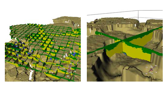
TNO | GEOLOGICAL MODELING
- Context / Objectives
– 3D geological model of the upper 30 m of the subsurface of the Netherland
– To provide a sound basis for subsurface related questions on groundwater extraction and infrastructural issues - Methods
– SGS and SIS for facies modeling
– Isatis batch procedures to automate the worflow - Outcomes
– 3D geological framework models and 3D volume models of which secondary products for applications can be extracted - Read the complete success story →
CEA | WATER QUALITY MODELING
- Context / Objectives: regional modeling of water quality
- Methods: collocated cokriging using available measurements, atmospheric deposits, and the output of a numerical model of hydrogeology
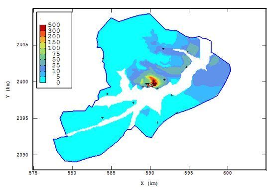
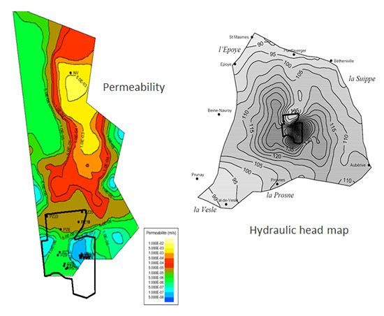
CEA | HYDROGEOLOGICAL MODELING
- Context / Objectives: environmental monitoring of CEA sites
- Methods
– Kriging of hydraulic head with Digital Elevation Model as external drift
– Special approach for permeabilities - Outcomes
– Hydraulic head estimates and permeability fields used as input/output data for solving the inverse problem
– Approach automated by CEA - Download →
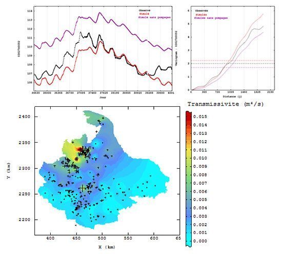
Further reading: Renard F., N. Jeannée (2008), Estimating transmissivity fields and their influence on flow and transport: The case of Champagne mounts. In Water Resources Research, 44, W11414, doi:10.1029/2008WR007033.
RHODIA – ARCADIS | HYDRAULIC BEHAVIOR OF A FORMER MINE
- Context / Objectives
– Former mine, now flooded
– Better knowledge of the hydraulic behavior
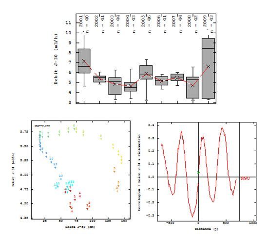
– Use of rainfall, the water level of the Loire river, piezometric and water levels inside the mine - Methods
– Statistitical tools, variograms, correlograms
– Temporal variations: delay between water levels, periodicities … - Outcomes
– Importance to work with 30-days means rather than instantaneous data
– Cyclic behavior between the Loire and the mine
– Different delays during the year
EDF | UNCERTAINTY EVALUATION
- Context / Objectives
– Complex hydrogeological model used to predict discharges in the Loire during low water level periods
– Uncertainties inventory, errors quantification
– New transmissivity fields - Methods
– Comparisons between data and simulation outputs
– New transmissivity fields using kriging - Outcomes
– Thorough list of uncertainties sources
– Tools for errors quantification assessment
– New calibration of the model using the kriged transmissivity fields
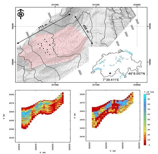
CREALP | ICE CONTENT EVALUATION WITHIN A GLACIER
- Context / Objectives
– Slow downward constant creep which constitutes an environmental hazard
– Lithology and ice content data - Methods
– Comparison of global ice volume between statistical estimation, 3D simulation and 3D simulation taking the lithology into account
– Facies modeling, plurigaussian simulations - Outcomes
– Statistical approach: ignore the data redundancy due to the spatial structure
– Plurigaussian Simulations produce more realistic results
ONDRAF | HYDROGEOLOGICAL MODELING
- Context / Objectives
– Deep repository of radioactive waste within geological barrier
– 3D modeling of key hydrogeological parameters to assess the quality of the geological barrier - Methods
– Review of database consistency
– 1D/3D modeling of target parameters using geophysical logs as auxiliary variables - Outcomes
– Validation of database
– Recommendations for further sampling locations & strategy
Further reading: Jeannée N., A. Berckmans, L. Wouters, J. Deraisme, J.-P. Chilès (2010), Quantifying the transferability of hydraulic parameters using geostatistics: the Boom Clay case, In Proceeding of the conference « Clays in Natural & Engineered Barriers for Radioactive Waste Confinement », Nantes, March 2010.

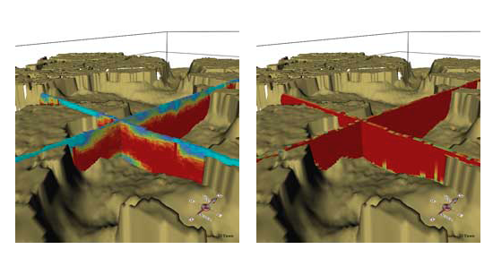
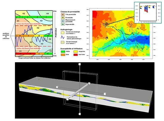
BRGM – SUEZ/LYONNAISE DES EAUX | GEOLOGICAL MODELING
- Context / Objectives
– RIVIERA project
– Assessment of the risk of water infiltration into the wastewater system - Methods
– Plurigaussian simulations
– 3D modeling of permeabilities
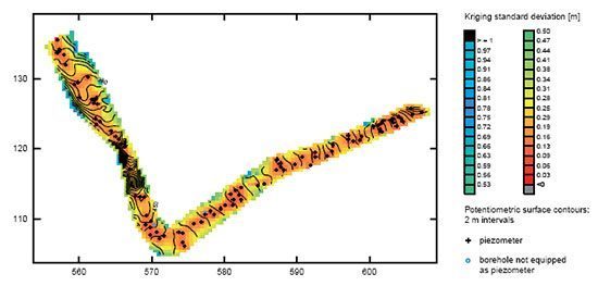
CREALP – COLENCO | OPTIMIZATION OF MONITORING NETWORK
- Context / Objectives
– Hydrogeological monitoring network of the Rhône-Alps valley
– Goal: reduce monitoring cost while preserving estimation quality - Methods
– Intrinsic kriging
– Kriging variance - Results: 20% decrease of the total number of piezometers
Mines ParisTech | WATER QUALITY MONITORING
- Context / Objectives: Nitrates modeling
- Methods
– Kriging and estimation of related confidence interval
– Evaluation of inconsistencies between data and model
Further reading: Flipo N., N. Jeannée, M. Poulin, S. Even, E. Ledoux. 2005. Assessment of nitrate pollution in the Grand Morin aquifers (France): combined use of geostatistics and physically-based modeling. In Environmental Pollution, 146 (2007) 241-256.
Mining (14)
Nuclear Decommissioning (9)
Contaminated sites (7)
Oil & Gas (6)
Hydrogeology (5)
TAGS:
2D/3D (2)
Background images (1)
Big data (1)
Conditional simulations (7)
Contaminated sites (2)
Contamination (2)
Drill Hole Spacing Analysis DHSA (3)
Excavation (2)
Facies modeling (2)
Flow modeling (1)
Geological modeling (3)
Gestion des sites pollués (2)
H2020 INSIDER (1)
Horizon mapping (1)
Ice content evaluation (1)
Isatis (11)
Isatis.neo (16)
Kartotrak (8)
Machine Learning (2)
Mapping (3)
MIK (2)
Mineral resource estimation (7)
Monitoring network optimization (1)
MPS (2)
Ore Control (1)
Pareto (2)
Pollution (2)
Post-accidental situation (2)
Recoverable resource estimation (3)
Resource classification (2)
Resources workflow (1)
Resource workflow (3)
Risk analysis (3)
Sample clustering (1)
Sampling optimization (3)
Scripting procedures (3)
Simulation post-processing (1)
Site characterization (2)
Soil contamination mapping (4)
Time-to-Depth conversion (1)
Uncertainty analysis (2)
Uniform Conditioning (5)
Variography (2)
Volumes (2)
Water quality modeling (1)
AUTHORS:
David Barry (3)
Yvon Desnoyers (2)
Pedram Masoudi (2)
Pedro Correia (1)
Catherine BLEINES (1)
DATES:
2023 (2)
2022 (3)
2021 (2)
2020 (2)
2019 (8)
2018 (4)
2017 (3)
2016 (3)