Quantify contaminated volumes quickly and accurately with Kartotrak’s “volumes & excavation” module
Posted on Kartotrak’s “Volumes & Excavation” workflow is a real decision-making tool. It enables precise cost-benefit analyses by quantifying the masses and volumes of soil to be treated according to different rehabilitation thresholds and the risk of residual pollution.
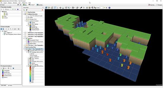
As part of contaminated site management, you need to quantify the volume of soil to be treated and establish the pollutant mass balance. Typically, you use several tools to (1) produce 2D maps of the polluted zone at different depths of the site, then, on each map, (2) delineate the surfaces exceeding a given remediation threshold, and finally (3) calculate the total volume impacted. All this can take quite some time. Did you know that with our Kartotrak software solution, you can quickly map in 3 dimensions and quantify the volume of pollution according to several remediation thresholds without leaving the software?
👇 Discover all the workflow possibilities 👇
Kartotrak is a complete software solution dedicated to characterizing chemical or radiological contamination. It enables a global approach, from the design and optimization of sampling plans to contamination mapping and the production of excavation plans, as well as the quantification of contaminated soil masses and volumes, taking uncertainties into account. It is built upon a GIS and a 3D Viewer and integrates a real-time measurement acquisition system, data analysis, and modeling tools based on geostatistics.
The “Volumes & Excavation” module is a Kartotrak-integrated workflow that allows you to:
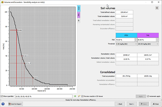
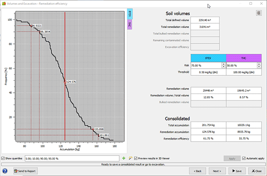
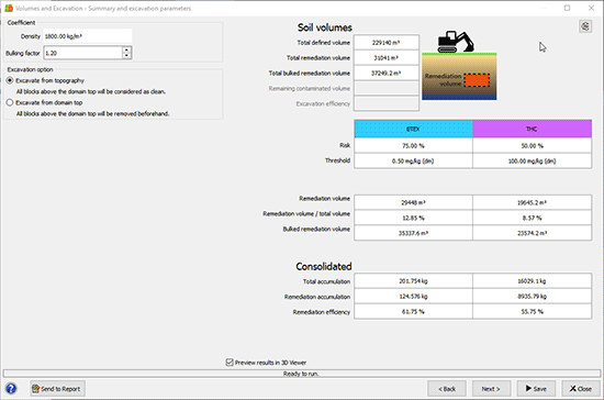
- Quantify in a robust way the masses and volumes of soil to be treated according to one or several remediation thresholds relative to different processes and future usage.
- Quickly evaluate the efficiency of several remediation scenarios according to the risk of leaving soil with contamination above a remediation threshold.
- Consider several thresholds at once for waste treatment route optimization.
- Test the Pareto approach for maximizing masses while minimizing volumes to achieve satisfactory cleanup under good economic conditions.
- Adopt a multi-pollutant and multi-layer approach for optimal remediation.
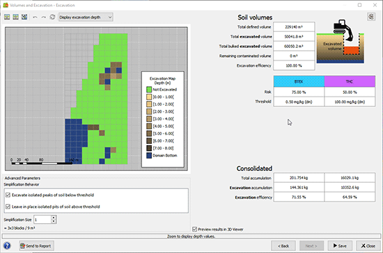
- Quickly deliver excavation plans and interactively adapt them to remediation constraints.
- Easily integrate geostatistical results into your mass balances and management plans using synthetic graphics, tables, and 3D visualization.
Mining (14)
Nuclear Decommissioning (9)
Contaminated sites (7)
Oil & Gas (6)
Hydrogeology (5)
TAGS:
2D/3D (2)
Background images (1)
Big data (1)
Conditional simulations (7)
Contaminated sites (2)
Contamination (2)
Drill Hole Spacing Analysis DHSA (3)
Excavation (2)
Facies modeling (2)
Flow modeling (1)
Geological modeling (3)
Gestion des sites pollués (2)
H2020 INSIDER (1)
Horizon mapping (1)
Ice content evaluation (1)
Isatis (11)
Isatis.neo (16)
Kartotrak (8)
Machine Learning (2)
Mapping (3)
MIK (2)
Mineral resource estimation (7)
Monitoring network optimization (1)
MPS (2)
Ore Control (1)
Pareto (2)
Pollution (2)
Post-accidental situation (2)
Recoverable resource estimation (3)
Resource classification (2)
Resources workflow (1)
Resource workflow (3)
Risk analysis (3)
Sample clustering (1)
Sampling optimization (3)
Scripting procedures (3)
Simulation post-processing (1)
Site characterization (2)
Soil contamination mapping (4)
Time-to-Depth conversion (1)
Uncertainty analysis (2)
Uniform Conditioning (5)
Variography (2)
Volumes (2)
Water quality modeling (1)
AUTHORS:
David Barry (3)
Yvon Desnoyers (2)
Pedram Masoudi (2)
Pedro Correia (1)
Catherine BLEINES (1)
DATES:
2023 (2)
2022 (3)
2021 (2)
2020 (2)
2019 (8)
2018 (4)
2017 (3)
2016 (3)