Optimizing flight-line distance for soil decontamination, application to contaminated Fukushima territories
Posted on IRSN, the French institute for radioprotection and nuclear safety, has been using Geovariances’ software solutions for many years to map radioactive contamination from airborne data. This study, conducted by IRSN and presented at ERPW 2018, demonstrates the influence of the variogram model on the map quality.
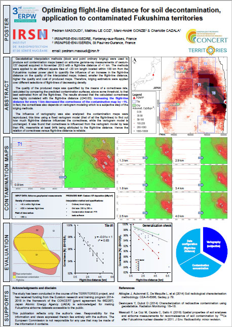
Geostatistical interpolation methods (block and point ordinary kriging) were used to produce soil contamination maps based on airborne gamma-ray measurements of cesium-137 deposit acquired in November 2013 with a flight-line distance of <1 km. The methods were applied to six different square tiles of ~20 km length located within 100 km from the Fukushima nuclear power plant to quantify the influence of an increase in the flight-line distance on the quality of the interpolated maps; indeed, smaller the flight-line distance, higher the quality and cost of produced maps. Therefore, kriging estimators were applied over different selections of flight-lines of decreasing density.
The quality of the produced maps was quantified by the means of a correctness rate, calculated by comparing the predicted contamination surfaces, above some threshold, to that best estimated from all the flight-lines. The results showed that the calculated correctness was highly correlated with the flight-line distance (r2=0.83): increasing the flight-line distance for every 1 km decreased the correctness of the contamination map by ~1%. In fact, the correctness also depends on variogram modeling which is a subjective step of the kriging methods.
The influence of variography was also analyzed: the contamination maps were reproduced, this time using a fixed variogram model (that of all the flight-lines) to find out how much flight-line distance influences the correctness, while the variogram model is unchanged. It was found that correctness is influenced by the variogram model by less than 6%, meanwhile at least 94% being attributed to the flight-line distance. Hence the relation of correctness versus flight-line distance is reliable.
Click the image to download the poster.
Poster presented at the 3rd Europe Radiological Protection Research Week ERPW 2018 in Rovinj-Rovigno, Croatia
Pedram MASOUDI (1), Mathieu LE COZ (1), Marc-André GONZE (2) & Charlotte CAZALA (1)
(1) IRSN/PSE-ENV/SEDRE, Fontenay-aux-Roses, France
(2) IRSN/PSE-ENV/SEREN, St Paul-les-Durance, France
To know more about how IRSN uses Kartotrak and what benefits they get from the software, read our success story made in partnership.
Mining (14)
Nuclear Decommissioning (9)
Contaminated sites (7)
Oil & Gas (6)
Hydrogeology (5)
TAGS:
2D/3D (2)
Background images (1)
Big data (1)
Conditional simulations (7)
Contaminated sites (2)
Contamination (2)
Drill Hole Spacing Analysis DHSA (3)
Excavation (2)
Facies modeling (2)
Flow modeling (1)
Geological modeling (3)
Gestion des sites pollués (2)
H2020 INSIDER (1)
Horizon mapping (1)
Ice content evaluation (1)
Isatis (11)
Isatis.neo (16)
Kartotrak (8)
Machine Learning (2)
Mapping (3)
MIK (2)
Mineral resource estimation (7)
Monitoring network optimization (1)
MPS (2)
Ore Control (1)
Pareto (2)
Pollution (2)
Post-accidental situation (2)
Recoverable resource estimation (3)
Resource classification (2)
Resources workflow (1)
Resource workflow (3)
Risk analysis (3)
Sample clustering (1)
Sampling optimization (3)
Scripting procedures (3)
Simulation post-processing (1)
Site characterization (2)
Soil contamination mapping (4)
Time-to-Depth conversion (1)
Uncertainty analysis (2)
Uniform Conditioning (5)
Variography (2)
Volumes (2)
Water quality modeling (1)
AUTHORS:
David Barry (3)
Pedram Masoudi (2)
Yvon Desnoyers (2)
Catherine BLEINES (1)
Pedro Correia (1)
DATES:
2023 (2)
2022 (3)
2021 (2)
2020 (2)
2019 (8)
2018 (4)
2017 (3)
2016 (3)