Use genetic models to constrain facies models and ensure accuracy and realism
Posted on Geological modeling in Isatis can be achieved using MPS methodology or Flumy, our applications for meandering system modeling. Do you know that you can combine both of them to ensure model accuracy and realism? See the tests done for a NOC.
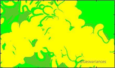
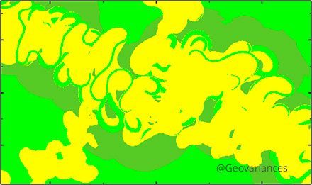
Geovariances has recently conducted some tests for a South-American Oil Company showing the advantage of combining process-based modeling techniques (Flumy) with MPS geostatistical simulation method for building accurate meandering geological models accounting for well data, deposition rules and complex geometric relationships between facies.
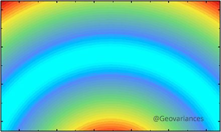
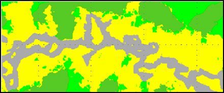
The idea has been to build first a training image with Flumy to be used as input of MPS. An erodability map has been defined to constrain the channel migration during the life of the turbiditic depositional system. Sand (Point Bars) is deposited preferentially in high erodibility areas.
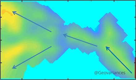
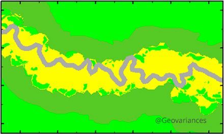
Then we have run MPS taking into account several auxiliary variables including local azimuths, local affinity and distance to channel. At simulation step, these variables allow to bring non-stationarity to a training image (note that two auxiliary variables can now be used simultaneously in Isatis).

This case study allowed demonstrating that combining Flumy with MPS has several advantages:
- Conditioning to data is easy
- Many controls are available and are easy to manage
- Flumy is an efficient way of getting 3D training images
- It takes into account training image variability
- Final model is realistic.
Mining (14)
Nuclear Decommissioning (9)
Contaminated sites (7)
Oil & Gas (6)
Hydrogeology (5)
TAGS:
2D/3D (2)
Background images (1)
Big data (1)
Conditional simulations (7)
Contaminated sites (2)
Contamination (2)
Drill Hole Spacing Analysis DHSA (3)
Excavation (2)
Facies modeling (2)
Flow modeling (1)
Geological modeling (3)
Gestion des sites pollués (2)
H2020 INSIDER (1)
Horizon mapping (1)
Ice content evaluation (1)
Isatis (11)
Isatis.neo (16)
Kartotrak (8)
Machine Learning (2)
Mapping (3)
MIK (2)
Mineral resource estimation (7)
Monitoring network optimization (1)
MPS (2)
Ore Control (1)
Pareto (2)
Pollution (2)
Post-accidental situation (2)
Recoverable resource estimation (3)
Resource classification (2)
Resources workflow (1)
Resource workflow (3)
Risk analysis (3)
Sample clustering (1)
Sampling optimization (3)
Scripting procedures (3)
Simulation post-processing (1)
Site characterization (2)
Soil contamination mapping (4)
Time-to-Depth conversion (1)
Uncertainty analysis (2)
Uniform Conditioning (5)
Variography (2)
Volumes (2)
Water quality modeling (1)
AUTHORS:
David Barry (3)
Yvon Desnoyers (2)
Pedram Masoudi (2)
Pedro Correia (1)
Catherine BLEINES (1)
DATES:
2023 (2)
2022 (3)
2021 (2)
2020 (2)
2019 (8)
2018 (4)
2017 (3)
2016 (3)